Module 3
Traffic Engineering & Control
Road User Characteristics
a) Physical Characteristics: vision, hearing, strength, fatigue, illness can reduce alertness and general reaction to traffic situations can affect quality of judgment and increase the reaction time
b) Mental Characteristics: knowledge, skill, intelligence, experience
c) Psychological Characteristics: attentiveness, fear, anger, superstition, impatience
d) Environmental Factors: traffic stream characteristics, atmospheric & weather conditions, locality
Vehicular Characteristics
a) Static Characteristics: dimension, weight, maximum turning angle
- Maximum Dimensions of Road Vehicles
Height of driver’s seat: affects the visibility distance
Maximum width = 2.5m
Maximum height: affects the clearance of overhead structures
a) Single decked vehicles = 3.8m
b) Double decked vehicles = 4.75m
Maximum length: affects capacity, overtaking distance and maneuverability
a) Singe unit truck with two or more axles = 11m
b) Singe unit bus with two or more axles = 12m
c) Semi-trailer tractor combinations = 16m
d) Tractor and trailer combinations = 18m
- Weight of Loaded Vehicles
Weight of loaded vehicles affects the design of pavement thickness and its gradient.
- Power of Vehicles
This governs the permissible and limiting gradients on road.
- Minimum Turning Radius of Vehicles
This depends upon the length of wheel base and features of the steering system.
This affects the design of sharp curves so as to negotiate vehicles at slow speeds.
b) Dynamic Characteristics: speed, acceleration
Speed & acceleration of the vehicle depend on power of the engine and the resistances to be overcome.
The stability of the vehicle and its safe movement on horizontal curves are affected by the width of wheel base and the height of C.G. Of the vehicle.
Braking Test is conducted to measure the skid resistance of pavement surface.
At least two of the three measurements are needed during braking test in order to determine the skid resistance of the pavement:
- Braking distance, L (m)
- Initial speed, u (m/s)
- Actual duration of brake application, t (s)
Related formulae:
- f =
 =
=  where,
f = skid resistance
u = initial speed in m/s
U = initial speed in kmph
Ii. v – u = at where,
u = initial speed in m/s
v = final speed in m/s
a = acceleration in m/s2
t = time in sec
But, v = 0 since brakes are applied and vehicle is brought to a halt. Also, u > v since initial speed of the vehicle is not zero.
Therefore, we can say that, u = at
Iii. v2 – u2 = 2as where,
u = initial speed in m/s
v = final speed in m/s
a = acceleration in m/s2
s = distance in m
But, v = 0 since brakes are applied and vehicle is brought to a halt. Also, u > v since initial speed of the vehicle is not zero.
Therefore, we can say that, u2 = 2as
But, from previous relation, u = at
Therefore, a2t2 = 2as
Or a = 2s/t2
Iv. F = ma where,
F = Force in kg-m/s2
m = mass in kg
a = acceleration in m/s2
The above equation can be written as follows:
f.w = 
Therefore, f =  where,
f = coefficient of friction
w = weight in kg
a = acceleration in m/s2
g = acceleration due to gravity in m/s2
Traffic Volume Study
Introduction
- It is the number of vehicles crossing a section of road per unit time at any selected period
- Expressed as vehicles/day or vehicles/hour
- Generally accepted as a true measure of relative importance of roads and in deciding the priority for improvement and expansion
- Used in planning, traffic operations and control of existing as well as new facilities
- Used in the analysis of traffic patterns and trends
- Used in geometric & structural design of pavements and in computing roadway capacity
- Pedestrian traffic volume studies help in planning sidewalks, crosswalks, subways and pedestrian signals
Methods for Traffic Volume Counts
- Manual counts: It is done by employing a field team to record traffic volume on prescribed record sheets
- Mechanical counters: Pneumatic hose, magnetic detector and radar detectors can be used to work throughout day and night for the desired period. However, this method does not allow segregation of traffic in to various classes of traffic in the stream and the details of traffic movements.
Presentation of Traffic Volume Data
- Annual Average Daily Traffic (AADT): helps in deciding the relative importance of a route and in phasing the road development program
AADT = 
2. Trend Charts: showing volume trends over a period of years
3. Variation Charts: showing hourly, daily and seasonal variations in traffic
4. Traffic Flow Maps: help to find the traffic volume distribution along existing roads at a glance
5. Volume Flow Diagrams: traffic volume diagrams needed for design of intersections
6. Thirtieth Highest Hourly Volume: hourly volume that will be exceeded only 29 times in a year; used as hourly volume for design
Speed Study
Important Terminology
- Travel time: reciprocal of speed and a simple measure of how well a road network is operating
- Spot speed: instantaneous speed of a vehicle at a specified section or location
- Average speed: average of spot speeds of all vehicles passing a given point on the highway
- Space mean speed: represents average speed of vehicles in a certain road length at any time
Vs = 
Where, Vs = space mean speed (kmph)
d = length of road (m)
n = number of individual vehicle operations
ti = observed travel time (sec) for ith vehicle to travel distance d
The average travel time of all vehicles is obtained from the reciprocal of space mean speed.
5. Time mean speed: represents the speed distribution of vehicles at a point on the roadway and it is the average of instantaneous speed of observed vehicles at the spot
Vt = 
Where, Vt = time mean speed (kmph)
n = number of individual vehicle operations
Vi = observed instantaneous speed of ith vehicle (kmph)
6. Running speed: average speed maintained by a vehicle over a particular stretch of road while the vehicle is in motion
7. Overall speed or Travel speed: effective speed with which a vehicle traverses a particular route between two terminals
There are two types of speed studies carried out:
a) Spot Speed Study
b) Speed & Delay Study
These are discussed as follows:
Spot Speed Study
Uses:
- In planning traffic control and in traffic regulations
- In geometric design
- In accident studies
- To study traffic capacity
Factors affecting spot speeds:
- Physical features of the road like pavement width, curve, sight distance, gradient and roadside developments
- Environmental conditions
- Enforcement
- Traffic conditions
- Driver, vehicle and motive of travel
Instruments used for finding spot speeds:
- Enoscope
- Radar speedometer
- Graphic recorder
- Electronic meter
- Photo-electric meter
Presentation of spot speed data:
a) Average speed of vehicles
- Frequency distribution tables are prepared by arranging the data
- Tables give general information of the speeds distribution pattern
b) Cumulative speed of vehicles
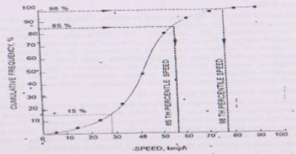
- 85th percentile speed is the speed at or below which 85% of the vehicles are passing the point on the highway. 15% of the vehicles exceed the speed at that spot. 85th percentile speed is also known as safe speed limit.
- 98th percentile speed is taken for the purpose of highway geometric design.
- 15th percentile speed represents the lower speed limit if it is desired to prohibit slow moving vehicles to decrease delay and congestion.
c) Modal Average
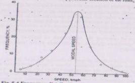
- Frequency distribution curve is plotted depicting the free flow of vehicles
Speed & Delay Study
Uses:
- Give the running speeds, overall speeds, fluctuations in speeds and delay between two stations of a road spaced far apart
- Give information such as amount, location, duration, frequency and causes of delay in the traffic stream
- Help to find the travel time and in benefit cost analysis
Types of delays:
- Fixed delay: occurs primarily at intersections due to traffic signals and at level crossings
- Operational delay: caused by interference of traffic movements such as turning vehicles, parking & unparking vehicles etc and by internal friction in traffic stream due to high traffic volume, insufficient capacity etc
Methods for carrying out speed & delay study:
- Floating Car Method
- A test vehicle is driven over a given course of travel at approximately the average speed of the stream.
- Detailed information is obtained concerning all phases of speed and delay including location, duration and causes of delay.
q = 
Where, q = flow of vehicles in one direction of the stream (volume per min)
na = average number of vehicles counted in the direction of the stream when the test vehicle travels in the opposite direction
ny = average number of vehicles overtaking the test vehicle when the test vehicle travels in the same direction
ta = average journey time when the test vehicle travels in the opposite direction as the stream (mins)
tw = average journey time when the test vehicle travels in the same direction as the stream (mins)
2. License Plate or Vehicle Number Method
- This method does not give important details such as causes of delay and duration etc.
3. Interview Technique
4. Elevated Photography & Observation Technique
Origin & Destination Study
Uses:
- To plan the road network and other facilities for vehicular traffic
- To plan the schedule of different modes of transportation for trip demand of commuters
- To judge the adequacy of existing routes and to use in planning new network of roads
- To locate expressways and major routes along the desire lines
- To establish preferential routes for various categories of vehicles
- To locate the intermediate stops of public transport
Methods of O&D Study:
- Roadside Interview Method
- Quick collection of data, simple method and team can be trained quickly
- Main drawback is that delays occur when vehicles are stopped for interview and it may even lead to resentment of the driver and passengers
2. License Plate Method
- Easy and quick method when the area under consideration is quite small
- Involves a lot of office compilations in tracing the trips through a network of stations
3. Return Post-card Method
- Suitable where traffic is heavy
4. Tag on car Method
- Suitable where traffic is heavy
- Pre-coded card is stuck on the vehicle to give information at the points of entry and exit into an area, thus indicating the time taken to traverse the area
5. Home Interview Method
- Additional data including socio-economic details etc may be collected so as to be useful for forecasting traffic & transportation growth
6. Work Spot Interview Method
- Involves collection of O&D data at work spots (offices, factories, educational institutions etc) by personal interviews
Parking Study
Parking facilities may be divided into two groups:
a) On-street or Kerb Parking
- Angle parking or parallel parking may be allowed on the kerb.
- Angle parking may be at angles 30ᵒ, 45ᵒ, 60ᵒ and 90ᵒ.
- Angle parking accommodates more number of vehicles per unit length of the kerb. Maximum parking capacity is achieved when vehicles are parked at 90ᵒ.
- Larger width of road is required for parking & un-parking operations, in case of angle parking. The requirement for larger width increases with increase in parking angle reaching maximum at 90ᵒ.
- Angle parking is more convenient but it also produces obstruction to the through-traffic. Therefore 45ᵒ angle parking is considered best from all considerations.
- Parallel parking is preferred when width of kerb parking space and the width of street are limited. But the parking and un-parking operations are more difficult and require many forward and reverse movements of the vehicle.
- Number of Spaces (N) available for parking for kerb length (L):
Parallel parking with equal spacing facing the same direction |  |
Parallel parking when two cars are placed closely |  |
30ᵒ angle parking |  |
45ᵒ angle parking |  |
60ᵒ angle parking |  |
90ᵒ angle parking |  |
b) Off-street Parking
- When parking facilities are provided at a separate place away from the kerb, it is known as off-street parking.
- Main advantage of this method is that there is no undue congestion and delay on the road.
- Main disadvantage is that the driver/passengers will have to walk greater distances after parking the vehicle as these parking facilities cannot be provided at very close intervals due to space unavailability.
- Two basic types of off-street parking facilities are:
- Parking Lots
Convenient where sufficient space is available at low costs.
May be self-parking system or attendant-parking system.
2. Multi-storey Parking Garages
Constructed where floor space is less and costly.
Accidental Study
Various objectives of accident studies may be listed as:
- To study the causes of accidents & suggest corrective measures at potential locations
- To evaluate existing designs
- To support proposed designs
- To carry out before and after studies and to demonstrate improvement in the problem
- To give economic justification of the suggested improvements
Four basic elements of traffic accident are:
- Road users
- Vehicles
- Road and its conditions
- Environmental factors – traffic, weather etc
Maintenance of Accident Records:
- Location files: useful to keep a check on the location of accident and to identify points of high accident incidence
- Spot maps: show accidents by spots, pins or symbols on the map of the affected area
- Condition diagram: drawing to scale showing all the important physical conditions of an accident location, including roadway limits, kerb lines, bridges, culverts, trees, signs, signals etc
- Collision diagram: diagram showing the approximate path of vehicles and pedestrians involved in accidents in order to compare the accident pattern before and after the remedial measures have been taken
Measures for reduction in accident rates:
- Engineering
- Road design
- Preventive maintenance of vehicles
- Before and after studies
- Road lighting
2. Enforcement
- Speed control
- Traffic control devices (signs, signals, markings, channelizing islands etc)
- Training & supervision
- Medical Check
- Observance of law & regulations
3. Education
- Education of road users
- Safety drive
Traffic Manoeuvre
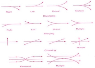
Types of Intersections
Important Concepts & Related Terminology
- Time Headway
- The time interval between the passage of successive vehicles moving in the same lane and measured from head to head as they pass a point on the road in known as the time headway.
2. Space Headway
- The distance between successive vehicles moving in the same lane measured from head at any instance is the space headway.

3. The number of headways per unit time depends on the rate of traffic flow and is therefore a direct measure of traffic volume.
4. With increase in speed of traffic stream, the minimum space headway increases whereas the minimum time headway first decreases and after reaching a minimum value at optimum speed, it increases.
5. Maximum flow or capacity flow is attained at optimum speed when the time headway is at minimum value.
6. Passenger Car Unit (PCU): It is the standard vehicle unit to convert other vehicle classes. Factors affecting PCU values are;
- Vehicle characteristics
- Transverse and longitudinal gaps
- Traffic stream characteristics
- Roadway characteristics
- Regulation and control of traffic
- Environmental and climatic conditions
IRC Recommendations for Tentative Equivalency Factors | ||
S.No. | Vehicle Class | Equivalency Factor |
1 | Passenger car, tempo, auto-rickshaw, agricultural tractor | 1.0 |
2 | Bus, truck, agricultural tractor-trailer unit | 3.0 |
3 | Motor cycle, scooter, pedal cycle | 0.5 |
4 | Cycle rickshaw | 1.5 |
5 | Horse drawn vehicles | 4.0 |
6 | Small bullock cart and hand cart | 6.0 |
7 | Large bullock cart | 8.0 |
7. Traffic Volume (veh/hour or veh/day): It is the number of vehicles moving in a specified direction on a given lane or roadway that pass a given point during specified unit of time
8. Traffic Density (veh/km): It is the number of vehicles occupying a unit length of lane of roadway at a given instant. It is the product of traffic density and traffic speed i.e. q = ku where,
q = traffic volume, veh/hr
k = traffic density, veh/km
u = speed of vehicle, kmph
Highest traffic density will occur when the vehicles are practically at a stand-still on a given route and in this case, traffic volume will approach zero.
9. Traffic Capacity (veh/hr/lane): It is the ability of a roadway to accommodate traffic volume. It depends on the prevailing roadway and traffic conditions.
Traffic volume ≤ Traffic Capacity
10. Basic Capacity: It is the maximum number of vehicles that can pass a given point on a lane or roadway during one hour under the most nearly ideal roadway and traffic conditions.
11. Possible Capacity: It is the maximum number of vehicles that can pass a given point on a lane or roadway during one hour under prevailing roadway and traffic conditions.
12. Practical Capacity or Design Capacity: It is the maximum number of vehicles that can pass a given point on a lane or roadway during one hour without any delay, hazard or restriction under prevailing roadway and traffic conditions.
Factors affecting Practical Capacity
- Lane width: As lane width decreases, capacity increases.
- Lateral Clearance: Vertical obstructions such as retaining walls or parked vehicles near the lane reduce the effective lane width and thus result in further reduction of capacity.
- Width of Shoulders: Narrow shoulders reduce the effective width of traffic lane as vehicles travel towards the center of the pavement.
- Commercial Vehicles: Trucks and buses occupy more space and travel at slow speeds.
- Alignment: If alignment and geometric design is not up to standards, the capacity will decrease.
- Presence of Intersection at Grades: Intersections restrict free flow and thus adversely affects capacity.
Determination of Theoretical Maximum Capacity
C = 
Where, C = Basic capacity of single lane (veh/hr)
V = Speed (kmph)
S = Average centre to centre spacing of vehicles = Sg + L (m)
Sg = Minimum space gap = 0.278Vt (m)
L = Average length of vehicle (m)
t = Reaction Time (sec) – Assumed value is 0.7 sec
Furthermore, the space gap allowed by the driver of a following vehicle depends on several factors such as:
- Speeds of leading & following vehicles
- Type & characteristics of the two vehicles
- Driver characteristics of the following vehicle
- Road geometrics
- Environmental factors
Phases of Traffic Regulation
- Driver controls: driving licenses, driver tests, financial responsibility, civil liability
- Vehicle controls: vehicle registration, requirements of vehicles, equipments & accessories, maximum dimension and weight, inspection of vehicles
- Flow regulations: directions, turning & overtaking
- General controls: to report accidents and traffic violation cases
Traffic Control Devices
Traffic control devices are signs, signals, pavement markings, and other devices that are placed along the roads to ensure safe and efficient movement of all road users.
- These are placed in key locations to guide and regulate movement of traffic, control speed of vehicles, and warn of potentially hazardous conditions at intersections, curves and dead ends.
- These also provide important information to users about detours and traffic delays.
- Enough markings must be available to the driver to give them important information but not so much as to distract them, thereby negatively affecting safety.
Communication tools
A number of mechanisms are used by the traffic engineer to communicate with the driver. Messages are conveyed through the following elements:
- Color: It is the first characteristic element discerned by the driver to reinforce specific messages. The most commonly used colors are red, green, yellow, black, blue, and brown.
- Shape: It is the second most easily noticed element of a device. The device may be circular, triangular, rectangular, and diamond in shape. Two exceptional shapes used are the octagonal shape for STOP sign and the inverted triangle for GIVE WAY (YIELD) sign.
- Legend: This is the last element of a device that the driver may comprehend. For the easy & quick understanding by the driver, the legend should be short, simple and specific. Symbols are used as legends so that even a person unable to read will be able to understand the sign.
- Pattern: It is used in road markings, complementing the traffic signs.Each pattern conveys different meaning. Generally solid, double solid and dotted lines are used.
- Traffic signs
There are various traffic signs available to cover a wide variety of traffic situations.
- On the kerb roads, the edge of the sign adjacent to the road should not be less than 0.6m away from the edge of the kerb.
- On roads without kerbs, the nearest edge may be 2m to 3m from the edge of the carriageway.
- The signs should be mounted on sign posts painted alternately with 25cm black and white bands.
They can be classified into three main categories:
- Regulatory signs: These signs inform the driver of certain laws, regulations and prohibitions, to ensure safety of other road users. Violation of these signs is a legal offence.
- Warning signs: These signs are used to warn the driver of certain hazardous conditions that exist on or adjacent to the roadway.
- Informative signs: These signs are used to guide the driver about the facilities available ahead on the route to make their travel easier, safe and pleasant.
In addition to these, certain special type of traffic sign namely work zone signs are also available. These signs are used to give warning to the road users when some construction work is going on the road. They are placed only for short duration and will be removed soon after the work is over and when the road is brought back to its normal condition.
a) Regulatory Signs
- These signs are also known as mandatory signs since it is mandatory for the drivers to obey these signs.
- Legal action can be taken against the driver if he fails to obey these.
- These signs encourage the driver to take care of the safety of other road users.
- These signs generally have black legend on a white background. These are circular in shape and have red borders.
- The regulatory signs can be further classified into the following sub-heads:
i. Right of way series
These include two unique signs: STOP sign and GIVE WAY sign.
When a minor road and a major road meet at an intersection, vehicles passing through the major road should be given preference. Therefore, the give way sign board will be placed on the minor road to inform the driver on the minor road that he should give way for the vehicles on the major road. In case two major roads are meeting, then the traffic engineer decides based on the traffic on which approach the sign board has to be placed.
Stop sign is another example of regulatory signs that comes in right of way series which requires the driver to stop the vehicle at the stop line.
The give way sign is octagonal in shape and red in colour with a white border.
The stop sign is triangular in shape with apex downwards and white in colour with a red border.
Ii. Speed series
Speed signs may be used to limit the speed of different classes of vehicles on the road.
These are circular in shape with black numerals, white background and red border.
Iii. Movement series
They are used to prohibit certain traffic movements, use of horns etc.
These include turn signs, alignment signs, exclusion signs, one way signs etc.
These are circular in shape with white background and red border.
Iv. Parking series
They include parking signs which indicate parking prohibitions or restrictions.
These signs indicate places where parking is permitted, the type of vehicle to be parked, duration for parking etc.
These are circular in shape with a blue background, red border and oblique red bar at an angle of 45ᵒ.
v. Pedestrian series
They include both symbol and legend signs.
These signs are for the safety of pedestrians and indicate pedestrian only roads, pedestrian crossing sites etc.
Vi. Miscellaneous
These include a "KEEP OF MEDIAN" sign, signs restricting vehicles carrying hazardous cargo or substances, signs indicating road closures, signs indicating vehicle weight limitations etc.
b) Warning signs
- Warning signs or cautionary signs warn the driver about the impending road condition that exists on or adjacent to the roadway.
- These signs are for the driver’s own safety.
- These are in the shape of an equilateral triangle with its apex upwards.
- They have white background, red border and black symbols.
Class of Road | Distance between two warning signs |
NH/ SH |
120 m |
MDR |
90 m |
ODR |
60 m |
VR |
40 m |
Urban Roads |
50 m |
c) Informative signs
- Informative signs are also known as guide signs
- They assist the drivers to reach their desired destinations.
- The informative signs can be further classified into the following sub-heads:
i. Direction & Place Identification signs
These include destination signs, direction signs, route markers and place identification signs.
The sign is rectangular in shape with white background, black border and black legends and symbols.
Ii. Facility information signs
These include petrol pump, public telephone, hospital, first aid etc.
The sign is rectangular in shape with blue background, and black/ white legends and symbols.
Iii. Parking signs
These are set-up parallel to the road.
The sign is square in shape with blue background and a white colored letter ‘P’.
Iv. Flood gauge signs
These are installed at all cause ways.
2. Traffic Signals
Advantages:
- Provide orderly movement of traffic and increase traffic handling capacity of most of the intersections at grade.
- Reduce accidents, notably right-angled collisions.
- Encourage reasonable speed along major traffic road.
- Provide a chance to traffic on minor roads to cross the path of continuous flow of traffic stream at reasonable intervals of time.
Disadvantages:
- Rear end collisions may increase.
- Improper design & location of signals may lead to violations of the control system.
- Failure of signal due to electric power failure may cause confusion to drivers.
Types of Traffic Signals:
- Traffic control signals
- Fixed time signals
- Manually operated signals
- Traffic actuated (automatic) signals
- Pedestrian signals
- Special Traffic signals
Important Terminology:
- Cycle: period of time required for one complete sequence of signal indications
- Phase: a part of signal cycle allocated to a single or a combination of traffic movements
- Interval: any division of the signal cycle during which signal indications do not change
IRC Guidelines:
- Pedestrian green time is calculated on the basis of walking speed of 1.2 m/sec and initial walking time of 7 sec.
- Cycle time is calculated after allowing amber time of 2 sec each.
- Minimum green time required for vehicular traffic on any of the approaches is limited to 16 sec.
3. Road Markings
- These are made up of lines, patterns, words, symbols or reflectors on the pavement, kerb, islands etc.
i. Pavement markings
Generally of white colour but yellow colour may also be used to indicate parking restrictions and for continuous center line and barrier line markings.
Width of pedestrian crossing may be 2-4 m depending on local requirements.
Ii. Kerb markings
These are made with alternate black and white lines.
Iii. Reflector unit markings
Reflect yellow light to guide drivers during night, ensuring safe driving.
Iv. Road delineators
Devices used to outline the roadway to provide visual assistance to drivers about the alignment of road ahead, especially at night.
4. Traffic Islands
- Raised areas constructed within the roadway to establish physical channel through which vehicular traffic may be guided.
i. Divisional Islands
To separate opposing flow of traffic on a highway with four or more lanes, hereby preventing head-on collisions
Ii. Channelizing Islands
To guide the flow of traffic into a proper channel through the intersection area
Iii. Pedestrian loading Islands
Provided at bus stops etc for the protection of pedestrians
Iv. Rotary
To channelize the flow of heavy traffic at an intersection
A road intersection is defined as a junction where two or more roads or streets meet or cross each other. Intersections may be classified into two broad groups:
a) Intersection at grade
- These include all roads which meet at more or less the same level.
- Traffic maneuvers including merging, diverging and crossing are involved in intersection at grade.
- Basic Requirements for Intersection at grade:
- At the intersection, the area of conflict should be as small as possible.
- The relative speed and angle of approach of vehicle should be small.
- Adequate visibility should be available to vehicles that approach the intersection.
- Sudden change of path should be avoided.
- Types of Intersections at Grade
- Un-channelized Intersections
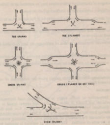
The intersection area is paved and there is no restriction to vehicles to use any area of the intersection.
Plain intersection: no additional pavement width for turning movement is provided
Flared intersection: pavement area is widened at the intersection area by one or more traffic lanes
B. Channelized Intersections
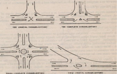
The intersection area consists of small islands in the intersection area, thereby reducing the total area of conflict at the intersection.
C. Rotary Intersections
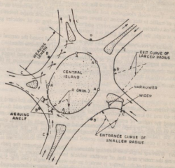
These are special form of at-grade intersections laid out for the movement of traffic in one direction around a central traffic island.
The vehicles entering the rotary are gently forced to move in a clockwise direction in an orderly manner.
Advantages:
a) Traffic flow is regulated to only one direction of movement, thus eliminating severe conflicts between crossing movements.
b) All vehicles entering a rotary are gently forced to reduce the speed and continue to move at slower speed. Thus, none of the vehicles need to be stopped.
c) Accidents and their severities are much less in rotaries.
d) Self-governing and do not need any control by police or traffic signals.
e) Ideally suited for moderate traffic.
Disadvantages:
a) All vehicles are forced to slow down and negotiate the intersection. Therefore, the cumulative delay is higher.
b) Vehicles are forced to reduce their speed even in low-traffic conditions.
c) Rotaries require large area of flat land making them costly at urban areas.
d) Cannot support large pedestrian traffic.
Guidelines for Selection of Rotary
a) Suitable when traffic entering from all four approaches is relatively equal.
b) A total volume of about 3000 vehicles per hour can be considered as the upper limiting case and a volume of 500 vehicles per hour is the lower limit.
c) Suitable when there are four or more than four approaches.
d) Very beneficial when proportion of right turning traffic is 30% of the total traffic.
Design Elements
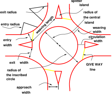
- Design Speed: 40 kmph for rural areas and 30 kmph for urban areas.
- Entry Radius: 20-35m for rural areas and 15-25m for urban areas.
- Exit Radius: 1.5-2 times of entry radius.
- Island Radius: 1.3 times of entry radius.
- Width of weaving section = Wweaving=
 ) + 3.5
Where, e1 = width of carriageway at entry
And e2 = width of carriageway at exit
- Weaving length is the minimum length of the rotary roadway that allows smooth merging and diverging of vehicles between the two channelizing islands of adjacent intersecting legs.
Weaving length= 4 x weaving width
Weaving length is 45-90 m for rural and 30-60 m for urban areas.
- Shape of Rotary depends upon the number and layout of the intersecting roads. The various shapes that may be used are circular, elliptical, turbine and tangential.
- Capacity of Rotary: Qw =
 where,
w = width of weaving section (within a range of 6-18m)
e = average entry width (in metres) (e/w ratio must be between 0.4-1)
l = weaving length (w/l ratio must be between 0.12-4)
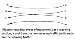
p = proportion of weaving traffic to non-weaving traffic (must be between 0.4-1) = 
Parking facilities may be divided into two groups:
c) On-street or Kerb Parking
- Angle parking or parallel parking may be allowed on the kerb.
- Angle parking may be at angles 30ᵒ, 45ᵒ, 60ᵒ and 90ᵒ.
- Angle parking accommodates more number of vehicles per unit length of the kerb. Maximum parking capacity is achieved when vehicles are parked at 90ᵒ.
- Larger width of road is required for parking & un-parking operations, in case of angle parking. The requirement for larger width increases with increase in parking angle reaching maximum at 90ᵒ.
- Angle parking is more convenient but it also produces obstruction to the through-traffic. Therefore 45ᵒ angle parking is considered best from all considerations.
- Parallel parking is preferred when width of kerb parking space and the width of street are limited. But the parking and un-parking operations are more difficult and require many forward and reverse movements of the vehicle.
- Number of Spaces (N) available for parking for kerb length (L):
Parallel parking with equal spacing facing the same direction |  |
Parallel parking when two cars are placed closely |  |
30ᵒ angle parking |  |
45ᵒ angle parking |  |
60ᵒ angle parking |  |
90ᵒ angle parking |  |
d) Off-street Parking
- When parking facilities are provided at a separate place away from the kerb, it is known as off-street parking.
- Main advantage of this method is that there is no undue congestion and delay on the road.
- Main disadvantage is that the driver/passengers will have to walk greater distances after parking the vehicle as these parking facilities cannot be provided at very close intervals due to space unavailability.
- Two basic types of off-street parking facilities are:
3. Parking Lots
Convenient where sufficient space is available at low costs.
May be self-parking system or attendant-parking system.
4. Multi-storey Parking Garages
Constructed where floor space is less and costly.
The main purpose of highway lighting is to enable the road users to see accurately and easily drive the vehicles. Majority of road accidents are caused at night and poor lighting is the main cause. Highway lighting is particularly more important at intersections, bridge sites, level crossings etc. It has the following advantages:
- Improved visibility at night by means of artificial lighting lessens the strain on driving and ensures comfort.
- The driver feels more confident in driving under proper street light.
- With better lighting, speed of traffic and traffic flow conditions improve.
- Proper street lighting ensures better police patrolling at night.
- Illegal actions and anti-social activities on roads are discouraged by improved lighting techniques.
- Street lighting ensures considerable reduction in accident rate during night.
- Factors affecting night visibility:
- Amount & reduction of light flux (radiant power given by the light source) from lamps
- Size of object
- Brightness of object
- Brightness of background
- Reflecting characteristics of pavement surface
- Glare on the eyes of the driver
- Time available to see an object
- Important Terminology:
Luminous flux – radiant power given out by light source (SI unit: lumen)
Lux – SI unit of illumination
Glare – condition of vision in which there is a discomfort or reduction in the ability to see significant objects or both, due to an unsuitable distribution of luminance (brightness)
Illumination – measure of light flux that falls on a surface
Lantern – a house for one or more lamps, comprising of a body and an ant refractor, reflector and diffuser
- IRC Recommendations:
Average level of illumination on important roads carrying fast traffic – 30 lux
Average level of illumination on other roads – 15 lux
Recommended mounting heights for lamps – 6 to 10 m (Higher values being preferred wherever possible, especially on urban roads)
As per IRC, 6m of minimum vertical clearance above the pavement surface has been recommended for electrical power lines up to 650 Volts
Horizontal clearance requirements for lighting poles:
a) For roads with raised kerbs (urban roads): Minimum 0.3m and desirable 0.6m from the edge of raised kerb
b) For roads without raised kerbs (rural roads): Minimum 1.5m from the edge of carriageway subject to a minimum of 5m from the centerline of the carriageway
- Lighting Layouts:
Single side lighting is economical but is suitable only for narrow roads.
For wide roads, the staggered system or the central lighting system may be adopted.
Lights are installed at closer spacing on curves than on straight paths.
Lights are located on the outer side of the curves to provide better visibility.
For simple intersections in urban areas, illumination should be at least equal to the sum of illumination values for two roads which form the intersection.
Reference Books:
5. S.K. Khanna and C.E.G. Justo - Highway Engineering - 10th Edition, Nem Chand and Bros. Roorkee
6. L.R. Kadiyali - Traffic Engineering and Transport Planning - Khanna Publishers