UNIT 4
INTRODUCTION TO SURVEYING AND LEVELLING
Surveying is the art of making measurements of objects on, above or beneath the ground to show their relative positions on paper. The relative position required is either horizontal, or vertical, or both. object of surveying is to show relative positions of various objects of an area.
On paper and produce plan or map of that area. Plans prepared to record property lines of private, public and government lands help in avoiding unnecessary controversies. Maps prepared for marking boundaries of countries, states, districts etc., avoid disputes. Locality plans help in identifying location of houses and offices in the area. Road maps help travellers and tourist. Topographic maps showing natural features like rivers, streams, hills, forests help in planning irrigation projects and flood control measures. For planning and estimating project works like roads, bridges, railways, airports, water supply and waste water disposal surveying is required.
To get accurate results in surveying one should follow the following fundamental principles:
(i) Work from whole to part
(ii) Take extra care in fixing new control points.
Work from Whole to Part: -
In surveying large areas, a system of control points is identified and they are located with high precision. Then secondary control points are located using lesser precise methods. The details of the localised areas are measured and plotted with respect to the secondary control points. This is called working from whole to part. This principle in surveying helps in localising the errors.
Surveying may be classified on the following basis:
(i) Nature of the survey field
(ii) Object of survey
(iii) Instruments used and
(iv) The methods employed.
Classification Based on Nature of Survey Field:
On this basis survey may be classified as land survey, marine or hydraulic survey and astronomical survey.
Land Survey. It involves measurement of various objects on land. This type of survey may be
further classified as given below:
(a) Topographic Survey: It is meant for plotting natural features like rivers, lakes, forests and hills as well as man made features like roads, railways, towns, villages and canals
(b) Cadestal Survey: It is for marking the boundaries of municipalities, villages, talukas, districts state etc. The survey made to mark properties of individuals also come under this category.
(c) City Survey: The survey made in connection with the construction of streets, water supply and sewage lines fall under this category.
Marine or Hydrographic Survey. Survey conducted to find depth of water at various points in bodies of water like sea, river and lakes fall under this category. Finding depth of water at specified points is known as sounding.
Astronomical Survey. Observations made to heavenly bodies like sun, stars etc., to locate absolute positions of points on the earth and for the purpose of calculating local time is known as astronomical survey.
Classification Based on Object of Survey
On the basis of object of survey, the classification can be as engineering survey, military survey, mines survey, geological survey and archaeological survey.
(a) Engineering Survey: The objective of this type of survey is to collect data for designing civil engineering projects like roads, railways, irrigation, water supply and sewage disposals. These surveys are further sub-divided into:
Reconnaissance Survey for determining feasibility and estimation of the scheme.
Preliminary Survey for collecting more information to estimate the cost of the project, and
Location Survey to set the work on the ground.
(b) Military Survey: This survey is meant for working out plans of strategic importance.
(c) Mines Survey: This is used for exploring mineral wealth.
(d) Geological Survey: This survey is for finding different strata in the earth’s crust.
(e) Archaeological Survey: This survey is for unearthing relics of antiquity.
Classification Based on Instruments Used
Based on the instruments used, surveying may be classified as:
(i) Chain survey
(ii) Compass survey
(iii) Plane table survey
(iv) Theodolite survey
(v) Tachometric survey
(vi) Modern survey using electronic distance meters and total station
(vii) Photographic and Aerial survey
Classification Based on Methods Employed
On this basis surveying is classified as triangulation and traversing.
(i) Triangulation: In this method control points are established through a network of triangles.
(ii) Traversing: In this scheme of establishing control points consists of a series of connected points established through linear and angular measurements. If the last line meets the starting point it is called as closed traverse. If it does not meet, it is known as open traverse.
Various methods used for linear measurements may be grouped as:
(i) Approximate
(ii) Using chain or tape
(iii) By optical means and
(iv) Using electromagnetic distance measurement instruments.
Terms Used in Chain Survey:
Station: Station is a point of importance at the beginning or at the end of a survey line Main station: These are the stations at the beginning or at the end of lines forming main skeleton. They are denoted as A, B, C etc.
Subsidiary or tie stations: These are the stations selected on main lines to run auxiliary/secondary lines for the purpose of locating interior details. These stations are denoted as a, b, c, ...., etc., or as 1, 2, 3, ... Etc.
Base line: It is the most important line and is the longest. Usually it is the line plotted first and then frame work of triangles are built on it.
Detail lines: If the important objects are far away from the main lines, the offsets are too long, resulting into inaccuracies and taking more time for the measurements. In such cases the secondary lines are run by selecting secondary stations on main lines. Such lines are called detail lines.
Check lines: These are the lines connecting main station and a substation on opposite side or the lines connecting to substations on the sides of main lines. The purpose of measuring such lines is to check the accuracy with which main stations are located.
Offsets
Lateral measurements to chain lines for locating ground features are known as offsets. For this purpose, perpendicular or oblique offsets may be taken. If the object to be located (say road) is curved a greater number of offsets should be taken. For measuring offsets tapes are commonly used.
For setting perpendicular offsets any one of the following methods are used:
(i) Swinging
(ii) Using cross staffs
(iii) Using optical or prism square
RANGING
When a survey line is longer than a chain length, it is necessary to align intermediate points on chain line so that the measurements are along the line. The process of locating intermediate points on survey line is known as ranging. There are two methods of ranging viz., direct ranging and reciprocal ranging.
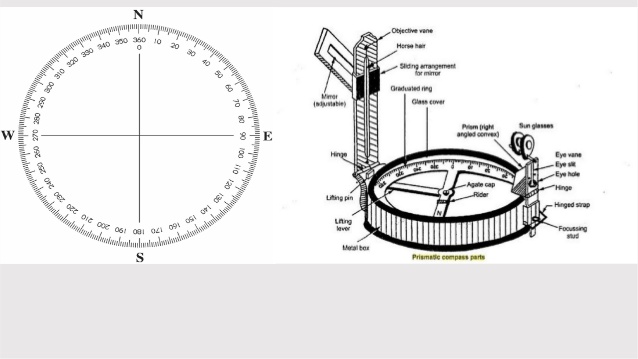
Compass is an instrument which can be used to measure the direction of a survey line with respect to magnetic north-south. The magnetic north-south direction which is the reference direction is called meridian (reference direction) and the angle between the line and the meridian is called bearing.
The types of compass that are used commonly are:
(i) prismatic compass
(ii) surveyor compass.
To take a reading from a compass, the following temporary adjustments are required:
(i) Centring:
The compass should be fixed to the stand and set over the station. To centre the compass legs of the tripod stand should be moved inward-outward or in a circumferential direction. To check centring plumb may be used or a pebble dropped from the centre of the compass.
(ii) Levelling:
In compass survey perfect levelling is not necessary, but it should be sufficient to permit free suspension of magnetic needle. For checking levelling a bubble level is provided in many compasses. After centring bubble should be ensured in the middle of the circle provided for it in the level. If it is not within that circle, circumferential movements may be provided to the legs of tripod so that without disturbing centring the levelling is achieved.
(iii) Focussing the prism:
In prismatic compass, to focus the prism on graduated circle, its attachment is slided up or down till the readings are clearly visible. There is no such requirement in surveyors’ compass.

A freely suspended and properly balanced magnetic needle is expected to show magnetic meridian. However, local objects like electric wires and objects of steel attract magnetic needle towards themselves. Thus, needle is forced to show slightly different direction. This disturbance is called local attraction.
The list of materials which cause local attraction are:
(i) magnetic rock or iron ore,
(ii) steel structures, iron poles, rails, electric poles and wires,
(iii) key bunch, knife, iron buttons, steel rimmed spectacles, and
(iv) chain, arrows, hammer, clearing axe etc.
As stated in the definition of levelling, the object is
(i) to determine the elevations of given points with respect to a datum
(ii) to establish the points of required height above or below the datum line.
Uses of levelling are
(i) to determine or to set the plinth level of a building.
(ii) to decide or set the road, railway, canal or sewage line alignment.
(iii) to determine or to set various levels of dams, towers, etc.
(iv) to determine the capacity of a reservoir.
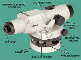
A level is an instrument giving horizontal line of sight and magnifying the reading at a faraway distance.
It consists of the following parts:
(i) A telescope to provide a line of sight
(ii) A level tube to make the line of sight horizontal and
(iii) A levelling head to level the instrument.
The following types of levels are available:
(i) Dumpy level (ii) Wye (or, Y) level
(iii) Cooke’s reversible level (iv) Cushing’s level
(v) Tilting level and (vi) Auto level.
 (Dumpy level)
TERMS USED IN LEVELLING
Before studying the art of levelling, it is necessary to clearly understand the following terms used in levelling:
1. Level Surface: A surface parallel to the mean spheroid of the earth is called a level surface and the line drawn on the level surface is known as a level line. Hence all points lying on a level surface are equidistant from the centre of the earth.
2. Horizontal Surface: A surface tangential to level surface at a given point is called horizontal surface at that point.
3. Vertical Line: A vertical line at a point is the line connecting the point to the centre of the earth. It is the plumb line at that point. Vertical and horizontal lines at a point are at right angles to each other
4. Datum: The level of a point or the surface with respect to which levels of other points or planes are calculated, is called a datum or datum surface
.
5. Mean Sea Level (MSL): MSL is the average height of the sea for all stages of the tides. At any particular place MSL is established by finding the mean sea level (free of tides) after averaging tide heights over a long period of at least 19 years. In India MSL used is that established at Karachi, presently, in Pakistan. In all important surveys this is used as datum.
6. Reduced Levels (RL): The level of a point taken as height above the datum surface is known as RL of that point.
7. Benchmarks: A benchmark is a relatively permanent reference point, the elevation of which is known (assumed or known w.r.t. MSL). It is used as a starting point for levelling or as a point upon which to close for a check. The following are the different types of benchmarks used in surveying:
(a) GTS benchmarks (b) Permanent benchmarks
(c) Arbitrary benchmarks and (d) Temporary benchmarks.
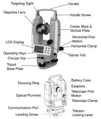
It is a commonly used instrument for measuring horizontal and vertical angles. It is used for prolonging a line, levelling and even for measuring the distances indirectly (tachometry). Using Vernier angles can be read accurately up to 20″. Precise theodolites are available which can read angles up to even 1″ accuracy. They use optical principle for more accurate instruments. Now a days electronic theodolites are also available which display the angles.

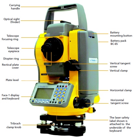
It is combination of EDM instrument and electronic theodolite. It is also integrated with microprocessor, electronic data collector and storage system. The instrument can be used to measure horizontal and vertical angles as well as sloping distance of object to the instrument. Microprocessor unit processes the data collected to compute:
1. Average of multiple angles measured
2. Average of multiple distance measured
3. Horizontal distance
4. Distance between any two points
5. Elevation of objects and
6. All the three coordinates of the observed points.
Data collected and processed may be down-loaded to computers for further processing. Total station is a compact instrument and weighs 50 to 55 N. A person can easily carry it to the field. Total stations with different accuracies, in angle measurement and different range of measurements are available in the market.

The station points used in surveying are to be identified before executing any project: For this purpose, surveyors used permanent objects as reference points and made reference sketches of station points. Navigators used sun and stars as references. Sometimes when the project is taken up the so-called permanent object (like building corner) may not exist when the execution of project work is taken up. For navigations weather conditions may obstruct the observations. Now a days this problem is over- come by using an instrument called Global Positioning System (GPS). This was developed by United States defence department and was called as Navigational System with Time and Ranging Global Positioning System (NAVSTAR) or which is now simply known as GPS.
There are 24 geostationary satellites positioned around the earth by US air force. These satellites are used as reference points to locate any point on the earth. These satellites are at an altitude of 20200 km above the earth. The 24 satellites are positioned such that from any point on the earth a minimum of 4 satellites are visible.
A user needs only GPS receiver. The receiver measures the travel time of the signals from satellites and calculate position (latitude and longitude) and the elevation altitude of the station with reference to a selected datum. The advantages of using GPS are:
1. Can be used in day as well as in night.
2. Intervisibility of the two stations on the earth is not a requirement.
3. Time required to establish the position of a point is much less.
4. Man power required is less.
5. Accuracy is high. Most expensive GPS provide accuracies within 10 mm.
Remote sensing may be defined as art and science of collecting information about objects, area or phenomenon without having physical contact with it. Eye sight and photographs are common examples of remote sensing in which sunlight or artificial light energy from electricity is made to strike the object. Light energy consists of electromagnetic waves of all length and intensity. When electromagnetic wave falls on the object, it is partly
1. Absorbed 2. Scattered
3. Transmitted 4. Reflected.
India is having its own remote sensing satellites like IRS-series, INSAT series and PSLV series.
Maps are used as the languages of simple geography. Importance of map making is recognised long ago. Surveyors went round the land and prepared maps. Data required for locating and calculating extent of a place/region is called spatial data.
Remote sensing and GIS go hand in hand, since lot of data for GIS is from remote sensing.
Remote sensing needs GIS for data analysis. Some of the areas of GIS application are:
1. Drainage systems
2. Streams and river basins management
3. Lakes
4. Canals
5. Roads
6. Railways
7. Land records
8. Layout of residential areas
9. Location of market, industrial, cultural and other utilities
10. Land use of different crops