Unit 3
Plane Table Surveying
Plane table surveying is a graphical method of survey in which the field observations and plotting are done simultaneously.
- It is simple and cheaper than theodolite survey. It is most suitable for small scale maps.
- The plan is drawn by the surveyor in the field, while the area to be surveyed is before his eyes. Therefore, there is no possibility of omitting the necessary measurements.
Accessories for Plane table surveying
1) Trough Compass
2) Spirit Level
3) U-Fork with Plumb bob
4) Water proof cover
5) Drawing paper
6) Pins
7) Drawing accessories
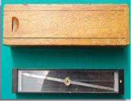
- Trough Compass
- The trough compass is required for drawing the line showing magnetic meridian on the paper. It is used to orient the table to the magnetic meridian.
- When the freely suspended needle shows 0 degree at each end, a line is drawn on the drawing paper which represents the magnetic north.

- Spirit Level
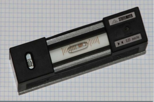
- A spirit Level is used for ascertaining if the table is properly level.
- The table is levelled by placing the level on the board in two positions at right angles and getting the bubble central in both positions.
- U-fork with Plumb bob
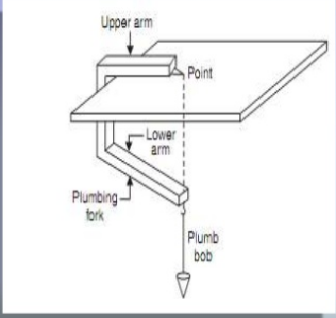
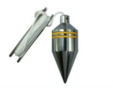
- U-fork with Plumb bob is used for cantering the table over the point or station occupied by the plane table when the plotted position of that point is already on the sheet
- Also, in the beginning of the work it is used for transferring the ground point on the sheet.
- Water Proof Cover
- An umbrella is used to protect the drawing paper from rain.

- Drawing paper
- Drawing paper is used for plotting the ground details.
Principle of Plane table surveying
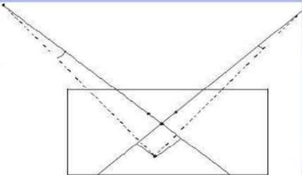
- All the rays drawn through various details should pass through the survey station.
- The position of plane table at each station must be identical i.e., at each survey station the table must be oriented in the direction of magnetic north.
Three process are involved in setting up the plane table-
1) Levelling
2) Cantering
3) Orientation
Levelling and Cantering-
- The table should be set up at convenient height for working on the board, say about 1m. The legs of tripod should be spread well apart and firmly into the ground.
- The table should be placed over the station on the ground that the point plotted on the sheet corresponding to the station occupied should be exactly over the station on ground. The operation is known as cantering of the plane table. It is done by U-FORK and PLUMB bob.
- For levelling the table ordinary spirit level may be used. The table is levelled by placing the level on the board in two positions at right angles and getting bubble central in both directions.
Orientation-
- The process by which the positions occupied by the board at various survey stations are key parallel is known as the orientation.
- Thys, when a plane table is properly oriented, the lines on the board are parallel to the lines on ground which they represent.
METHODS OF PLANE TABLING-
There are four methods of plane tabling-
1) Method of radiation
2) Method of intersection
3) Method of traversing
4) Method of resection
METHOD OF RADIATION-
- In the radiation method of plane table surveying, the direction of the objects or points to be located are obtained by drawing radial lines along fiducially edge of alidade after getting the objects or points bisected along the line of sight of the alidade.
- The horizontal distance then measured and scaled off on the corresponding radial lines to mark their positions on the drawing.
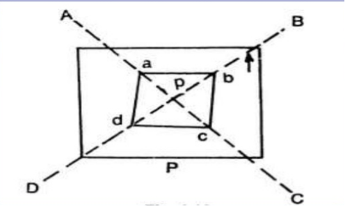
- Suppose P is a station on the ground from where the object A, B, C and D are visible.
- The plane table is set up over the station P.A drawing is fixed on the table, which is then levelled and cantered. A point P is selected on the sheet to represent the station P.
- The north line is marked on the right-hand top corner of the sheet with trough compass or circular box compass.
- With the alidade touching P, the ranging rod at A, B, C and D are bisected and the rays are drawn.
- The distance PA, PB, PC and PD are measured and plotted to suitable scale to obtain the points a, b, c and d representing A,B,C,D on paper.
METHOD OF INTERSECTION –
- In intersection method of plane table surveying, the objects or points to be located are obtained at the point of intersection of radial lines drawn from two different stations.
- In the method, the plotting of plane table sections is to be carried out accurately. Checking is important and thus done by taking third sight from another station.
- The intersection method is suitable when distances of objects are large or cannot be measured properly. Thus, this method is preferred in small scale survey and for mountainous regions.
- Suppose A and B are two station and P is the object on the far bank of a river. Now it is required to fix the position of P on the sheet by the intersection of rays, drawn from A and B.
- The table is set up at A. It is levelled and cantered so that a point a on the sheet is just over the station A. The north line is marked on the right-hand too corner, the table is then clamed.
- With the alidade touching a, the object P and the ranging rod at B are bisected, and rays are drawn through the fiducial edge on alidade.
- 
- The distance AB is measured and plotted to any suitable scale to obtain point b.
- The table is shifted and cantered over B and levelled properly. Now the alidade is placed along the line ba and orientation is done by back sighting.
- With the alidade touching b, the object P is bisected and a ray is drawn, suppose this ray intersects the previous rays at point p, the point p is the required plotted position of P.
METHOD OF TRAVERSING
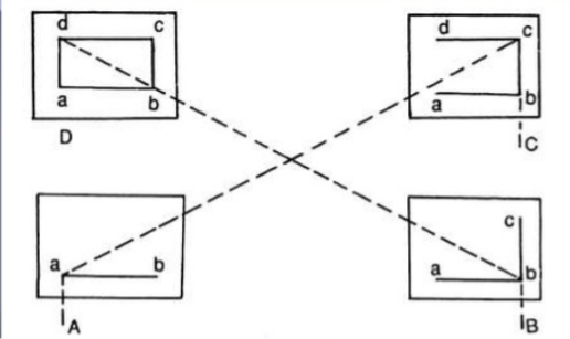
- This method of plane table surveying is used to plot a traverse in case stations have not been previously plotted by some other methods. In this method, traverse stations are first selected. The stations are plotted by method of radiation by taking back sight on the preceding station and a fore sight to the following station. Here, distances are generally measured by tachometric method and surveying work has to be performed with great care.
- Suppose A, B, C, D are the traverse stations.
- The table is set up the station A, a suitable point a is selected on the sheet in such a way that the whole area may be plotted in the sheet. The table is cantered, levelled and clamped. The north line is marked on the right-hand top corner on the sheet.
- The table is shifted touching point the ranging rod at B is bisected and a ray is drawn. The distance is measured and plotted to any suitable scale.
- The table is shifted and cantered over B. It is then levelled, oriented by back sighting and clamped.
- With alidade touching point b, the ranging rod at C is bisected and ray is drawn. The distance BC is measured and plotted to the same scale
- The table is shifted and set up at C and the same procedure is repeated
- In this manner, all station of the traverse is connected.
METHOD OF RESECTION-
- Resection is the process of determining the plotted position of the station occupied by the plane table, by means of sights taken towards known points, locations of which have been plotted.
- There are four methods of resection-
1) By Compass
2) By basic sighting
3) By two-point problem
4) By three-point problem
APPLICATION OF PLANE TABLE SURVEYING-
(1) Map of the area is plotted in the field, i.e., both the field work and the plotting are done simultaneously.
(2) Field notes of the measurements are not required, and thus the errors in booking are eliminated.
(3) The correctness of plotted work can be checked by check observations in the field.
(4) Office work is only finishing up of the drawing.
(5) Direct measurements of lines and angles are avoided as they are obtained graphically.
(6) Errors due to extended angular observations with angular instruments and incorrect plotting with bad protractors are avoided.
(7) This is suitable in a magnetic area where you can’t rely on the compass survey.
(8) More work will be done in less time and labor.
(9) It is less costly than a theodolite survey.
(10) It is most suitable for preparing small-scale maps.
(11) Contours and irregular objects may be represented accurately.
(12) The reduced levels of points other than the station points of known elevations may be found out with the help of a tangent clinometer.
(13) The survey can be completed very rapidly.
(14) Much skill is not required to prepare a map.
(15) The danger of omitting the necessary measurement is eliminated as the survey is plotted in the field.
Reference Books:
1. Principles of Surveying. Vol. I by J. G. Olliver, J. Clendinning - Van Nostrand
Reinhold.
2. Plane Surveying by A. M. Chandra, New Age International Publishers.
3. Surveying Vol. I & II by Dr. K. R. Arora, Standard Book House.
4. Plane surveying – David Clark.