Unit- 3
Physical Geology
Q1) Explain what is physical geology and what is weathering?
A1)
Weathering
Physical Weathering
The mechanical breakup or disintegration of rock doesn't change mineral makeup. It creates broken fragments or “detritus.” which are classified by size:
Physical weathering takes place through a variety of processes. Among them are:
Joints form as a result of expansion due to cooling or relief of pressure as overlying rocks are removed by erosion.
Igneous plutons crack in onion-like “exfoliation” layers. These layers break off as sheets that slide off of a pluton. Over time, this process creates domed remnants.
Joints form free space in the rock by which other agents of chemical or physical weathering can enter.
Q2) Explain what is chemical weathering?
A2)
Since many rocks and minerals are formed under conditions present deep within the Earth, when they arrive near the surface as a result of uplift and erosion, they encounter conditions very different from those under which they originally formed. Among the conditions present near the Earth's surface that are different from those deep within the Earth are:
Because of these differing conditions, minerals in rocks react with their new environment to produce new minerals that are stable under conditions near the surface. Minerals that are stable under P, T, H2O, and O2 conditions near the surface are, in order of most stable to least stable:
Note the minerals with a *. These are igneous minerals that crystallize from a liquid. Note the minerals that occur low on this list are the minerals that crystallize at high temperatures from magma. The higher the temperature of crystallization, the less stable are these minerals at the low temperature found near the Earth's surface (see Bowen's reaction series in the igneous rocks chapter).
The main agents responsible for chemical weathering reactions are water and weak acids formed in water.

H+ is a small ion and can easily enter crystal structures, releasing other ions into the water.
Q3) Explain the types of chemical weathering and what are the factors that influence weathering?
A3)
Types of Chemical Weathering Reactions


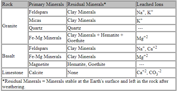
Weathering of Common Rocks
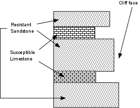
Factors that Influence Weathering
Q4) What is erosion?
A4) Erosion
Erosion is the removal of surface material from Earth’s crust, primarily soil and rock debris, and the transportation of the eroded materials by natural agencies (such as water or wind) from the point of removal.
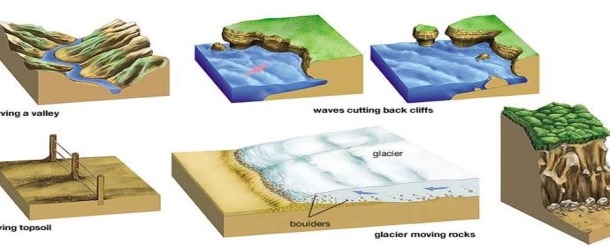
Fig: Erosion
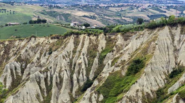
Fig: Gullies in an eroded hill in Atri, Italy.
Q5) Explain water erosion in detail.
A5) Water Erosion
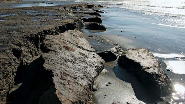
Fig: Beach erosion
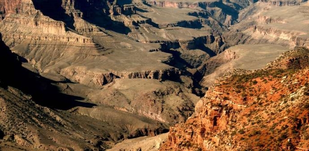
Fig : Eroded valley
Q6) What is glacial erosion and wind erosion? Explain what is denudation?
A6) Glacial Erosion
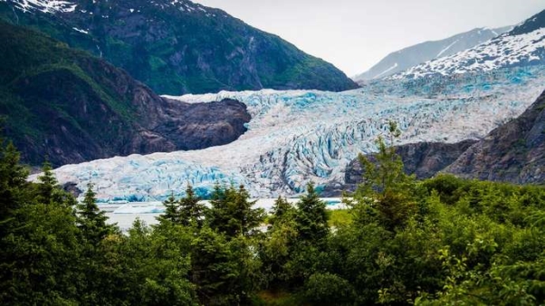
Fig: Glacial erosion
Wind Erosion
In some arid and desert tracts, the wind has an important effect in bringing about the erosion of rocks by driving sand, and the surface of dunes not held together and protected by vegetation is subject to erosion and change by the drifting of blown sand. This action erodes material by deflation—the removal of small loose particles—and by sandblasting of landforms by wind-transported material. Continued deflation of loose particles from landforms leaves behind larger particles that are more resistant to deflation. Wind action transports eroded material above or along the surface of Earth either by turbulent flow (in which particles move in all directions) or by laminar flow (in which adjacent sheets of air slip past one another). The transportation of wind-eroded material continues until the velocity of the wind can no longer sustain the size particle being transported or until the windblown particles collide with or cling to a surface feature.
Denudation
Force and resistance
Q7) What are the factors affecting weathering?
A7) Factors affecting Weathering.
Climate:
This is the most important factor affecting weathering of rocks. The extent of weathering is dependent on the average atmospheric condition prevailing in a region over a long time.
Two factors play in weathering, viz. Temperature and Precipitation. Warm climates affect by chemical weathering while cold climates affect by physical weathering (particularly by frost action). In either case, the weathering is more pronounced with more moisture content.
At higher temperatures, chemical reactions are likely to take place faster. Chemical reactions in most cases need water which is a reactant in hydration and carbonation. Water is also the medium in which the reaction can take place.
Biological activities are supported by hot moist climates. For instance, burrowing humic acid production during the decomposition of plant matter is most likely in hot moist climates. A hot moist climate provides the most ideal environment for fast chemical weathering.
Physical weathering by frost action is most likely in a cold climate where freeze and thaw occur alternately during the cold weather. In this case, again precipitation is the main factor. In the absence of water, ice cannot form, and frost action is not possible. Hence an effective frost action occurs in the cold moist climate.
1. Particle Size:The rate of chemical weathering is affected by the size of rock particles. If the rock pieces are smaller, the weathering is faster. This is because if the rock pieces are smaller, the surface area exposed to weather action is greater.
2. Exposure:The extent of exposure i.e. the extent to which the rock comes into contact with the agents of weather is an important factor affecting the weathering. In some situations, vegetation, soil, ice, etc. may cover a rock, thereby reducing the area exposed to weather action.
Such rocks so protected weather slowly compared to rocks whose surfaces are wholly exposed to the weather. The slope of the region is also a factor affecting weathering. Where the slopes are steep, loose materials are displaced downhill either by gravity or by erosion resulting in continuous exposure of the fresh rock.
3. Mineral Composition:We know, the chemical properties of a rock depend on the mineral composition to a great extent. Mineral in a rock may readily react with acids, water, or oxygen causing considerable weathering. For example, limestone can get severely acted upon by even very mildly acidic rainwater. Granite on the contrary mostly containing silica remains unaffected by such agents.
Physical weathering is also dependent on mineral composition. Soft rocks are liable to be abraded more readily than hard rocks. The solid crystalline rocks are quite compact with very little opening and are very resistive to the entry of water into them, and can therefore resist weathering.
4. Time:The process of weathering is a time taking process. The duration of time for which rock is exposed to weather determines the extent of weathering. Very strong rocks, however strong they might be will severely undergo weathering in hundreds of years
Q8) Explain the products of weathering.
A8) Products of weathering
1. Landforms created by weathering
Disintegration landforms
Solution Landforms: Karst
Removal of the weathered by products by erosion is an integral part of any landform development, and there are an infinite variety of landforms created by differential weathering and erosion. A few landforms, where the form is dominated by the style of weathering are presented here, others are covered later under other sections.
2. Sediment and soils
Weathering and erosion fine-tune the landscape. Tectonics and internal adjustments rough it out, but weathering and erosion etch it, cover it, and create many of the fine details. I use the term disintegration landforms for features created by mechanical and chemical weathering acting on largely insoluble rocks. These landforms reflect styles of disintegration and differential weathering. In contrast, solution landforms are formed in the soluble rock. These features are covered in the karst outline.
Disintegration landforms
Inselbergs, tors, and bonharts and exfoliation domes
Inselbergs
Inselbergs (german, island hill) are isolated rock hills created by long-term weathering and erosion. Bonharts and tors are varieties of inselbergs. These hills are steep-sided and typically lack talus at the base suggesting that they were created by deep weathering and exhumation rather than dissection and slope retreat. Joints play an important role in their formation.
Tors
Tors (Fig 3.7b) are residual rock masses that display as isolated piles of boulders. Although they typically form in granite they also developed in other lithologies. Linton (1955) theorized a two-stage process of formation. The first involves the deep penetration of weathering along jointed bedrock, which produces a thick saprolite mantle intersperse with unweathered core stones (Fig. 3.7 a). The second stage is brought on by exhumation either by tectonic uplift or lowering of base level. The granular saprolite is quickly removed from wind and water leaving behind the rounded core stone (Fig. 3.7b).
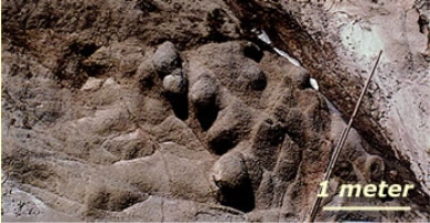
Fig a. Deeply weathered granite in the Sierra Nevada Mts
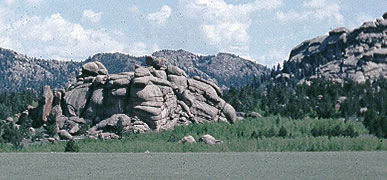
Fig b. Granite tors
Bornhardts
Bornhardts are distinct steep-sided, dome-shaped hills. Unlike tors, they are composed of relatively unjointed rock, except for large curved surface joints. These large rounded monoliths are purported to be formed by exfoliation following the removal of neighbouring weak rock. Probably the two most famous bornhardts are Half Dome in Yosemite Valley, CA, and Ayers Rock in Australia. Bornhardts are largely isolated exfoliation domes. Not all bornhardts are necessarily considered inselbergs. Half Dome for example, no longer rises above a plain but rather a rugged glaciated alpine landscape. As with tors, exhumation is most likely is important in their development.
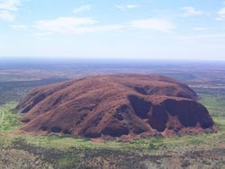
Fig : Ayers Rock (Uluru)
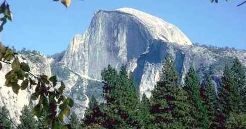
Fig : Half Dome
Q9) Explain weathering pits in detail, what is tafoni, rubble fields and slopes, fines hoodos.
A9) Weathering Pits
Weathering pits are depressions created where water ponds in irregularities on rock surfaces. The trapped water localizes chemical weathering and granular disintegration. Wind and water remove the loosened grains and the depressions enlarge trapping more water in a positive feedback cycle.
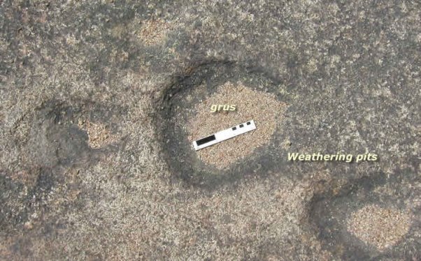
Fig : Weathering pits
Tafoni (small caverns)
Tafoni is a unique type of pitted surface formed by alveolar (honeycomb) weathering, a style of weathering resulting from salt weathering, and differential solution and precipitation of solutes in sandstones having a soluble cement. The weathering creates pocket-like caverns on rock surfaces, usually sandstones with calcareous cement.
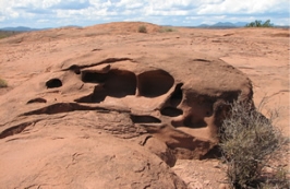
Fig: Tafoni
Rubble fields and slopes
Fields and slopes of blocky rubble are common in an alpine and periglacial setting where freeze-thaw dominates. Examples of such features include:
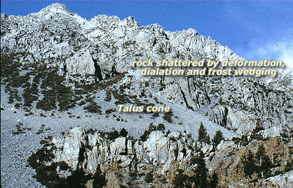
Fig: Talus (scree slope)
Fins, Alcoves, arches, and hoodoos
These are unique features formed by varying styles of disintegration and erosion of horizontally bedded and vertically jointed rock. They are common features of the Colorado Plateau Province.
Fins
Fins are residual walls of rock that remain after the adjacent rock has been removed along with systematic parallel joint sets. Such joints are typically formed by tensional stresses along anticlinal or monoclinal fold axes. The joints leading to the creation of the Courthouse Towers (fig. 3.13) in Arches National Park formed a thick sandstone (Slickrock Member of the Kayenta Formation) and are attributed to the deformation and subsequent collapse of the salt-cored anticline.
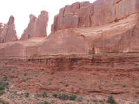
Fig: Fins
Hoodoos
Hoodoos are rock pinnacles formed by differential weathering and erosion of vertically-jointed horizontal beds of shale interbedded with thin resistant beds of limestone, sandstone, or conglomerate. The best examples and type locality of hoodoos occur in Bryce Canyon, Utah.
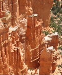
Fig : Hoodoos
Q10) What is alcoves and arches, regolith overburden
A10) Alcoves and Arches
Alcoves and arches are weathering features common in the dissected horizontal strata of the Colorado Plateau. They form where chemical and physical weathering is concentrated along horizontal discontinuities where water and salts concentrate, such as the contact between sandstone and underlying shale bed. Once formed, an alcove enlarges, often through exfoliation. Indians in the American Southwest built cliff dwellings in natural alcoves, enlarging them by digging out any soft weathered rock and using jointed blocks to enclose them. Arches form where alcoves breakthrough residual fins of rock created by erosion along joints.
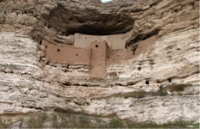
Fig. Alcove
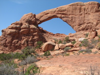
Fig. North Window arch
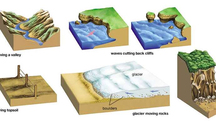
Fig. Alcoves, arches, and hoodoos
Regolith, Overburden
The general definition of the above terms: Disintegrated and decomposed mineral and organic matter occurring naturally on the surface of the earth.
Regolith and Overburden:
The terms regolith and overburden are general terms applied to any sediment overlying bedrock. They may be transported or formed insitu by weathering. Transported regolith includes glacial, fluvial, colluvial, lacustrine, marine, or aeolian deposits. Except for rare saprolite localities, the regolith in New England and the Upper Midwest is transported, mostly by glaciers and their meltwater by-products. Insitu soils are found south of the glacial limit. Transported regolith also occurs in alluvial valleys and deserts.
More Terms
Q11) What are the engineering consideration of weathering, superficial deposits and their types in detail.
A11)
Engineering considerations
Engineering Considerations of Weathering are as follows –
Superficial Deposits
Superficial deposits refer to geological deposits typically of Quaternary age (less than 2.6 million years old). These geologically recent unconsolidated sediments may include stream channel and floodplain deposits, beach sands, talus gravels, and glacial drift and moraine. All pre-Quaternary deposits are referred to as bedrock.
Types
There are several types of superficial deposits, including raised beaches and brick-earth. These were formed in periods of climate change during the ice ages. The raised beaches were generally formed during periods of higher sea level when ice sheets were at a minimum, and the sand and shingle deposits can be seen in many low cliffs. The brick-earth is originally wind-blown dust deposited under extremely cold, dry conditions but much has been re-deposited by floodwater and mixed with flints.
Superficial deposits were originally recorded only onshore and around the coast where they were laid down by various natural processes such as action by ice, water, and wind. More recently offshore deposits have been mapped and may be separate sea-bed sediments.
Most of these superficial deposits are unconsolidated sediments such as gravel, sand, silt, and clay, and onshore they form relatively thin, often discontinuous patches. Almost all of these deposits were formerly classified based onthe mode of origin with names such as, 'glacial deposits', 'river terrace deposits' or 'blown sand'; or on their composition such as 'peat'.
Categories | Types of superficial deposits |
Generally high permeability | Blown sand Glacial sand and gravel Raised beach and marine deposits River terrace deposits (mainly sand and gravel) Sand and gravel of uncertain age and origin |
Generally low permeability | Clay with flints Lacustrine flints, silts, and sands Peat |
Mixed permeability | Alluvium (including River Terrace deposits in Scotland) Boulder clay and morainic drift Brickearth, mainly loess Landslip |
Table
Importance
Superficial deposits (residual, colluvial, alluvial) are important as environmental resources in tropical environments. An understanding of their formation through varying periods is essential to a correct interpretation of their economic and hazard potentials. This requires an integration of process studies with a reconstruction of longer-term development. Saprolite formation is considered over 105‐107 yr, while colluvial and alluvial sediments are commonly Late Quaternary (103‐105 yr) in age. It is seen that geomorphologists can often make their most important contributions to developing areas by offering a sound interpretation of land surfaces and their underlying deposits for engineers, geologists, and pedologists, with whom a close working relationship is essential.
Q12) Explain water fall in detail.
A12)
Waterfall
A waterfall is a river or other body of water's steep fall over a rocky ledge into a plunge pool below. Waterfalls are also called cascades. The process of erosion, the wearing away of earth, plays an important part in the formation of waterfalls. Waterfalls themselves also contribute to erosion.
Often, waterfalls form as streams flow from soft rock to hard rock. This happens both laterally (as a stream flows across the earth) and vertically (as the stream drops in a waterfall). In both cases, the soft rock erodes, leaving a hard ledge over which the stream falls.
A fall line is an imaginary line along which parallel rivers plunge as they flow from uplands to lowlands. Many waterfalls in an area help geologists and hydrologists determine a region's fall line and underlying rock structure.
As a stream flows, it carries sediment. The sediment can be microscopic silt, pebbles, or even boulders. Sediment can erode stream beds made of soft rock, such as sandstone or limestone. Eventually, the stream's channel cuts so deep into the stream bed that only a harder rock, such as granite, remains. Waterfalls develop as these granite formations form cliffs and ledges.
A stream's velocity increases as it nears a waterfall, increasing the amount of erosion taking place. The movement of water at the top of a waterfall can erode rocks to be very flat and smooth. Rushing water and sediment topple over the waterfall, eroding the plunge pool at the base. The crashing flow of the water may also create powerful whirlpools that erode the rock of the plunge pool beneath them.
The resulting erosion at the base of a waterfall can be very dramatic, and cause the waterfall to "recede." The area behind the waterfall is worn away, creating a hollow, cave-like structure called a "rock shelter." Eventually, the rocky ledge (called the outcropping) may tumble down, sending boulders into the stream bed and plunge pool below. This causes the waterfall to "recede" many meters upstream. The waterfall erosion process starts again, breaking down the boulders of the former outcropping.
Erosion is just one process that can form waterfalls. A waterfall may form across a fault, or crack in the Earth’s surface. An earthquake, landslide, glacier, or volcano may also disrupt stream beds and help create waterfalls.
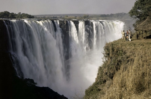
Fig. Victoria Falls, Zimbabwe
Classifying Waterfalls
Q13) Explain types of water fall in detail.
A13) Types of Waterfalls
One of the most popular, if least scientific, ways to classify waterfalls is by type. A waterfall's type is simply the way the descends. Most waterfalls fit more than one category.
ii. A cascade is a waterfall that descends over a series of rock steps. Monkey Falls, in the Indira Gandhi Wildlife Sanctuary and National Park in Tamil Nadu, India, is a gently sloping cascade. The waterfall is safe enough for children to play in the water.
iii. A cataract is a powerful, even dangerous, waterfall. Among the widest and wildest of cataracts are the thundering waters of the Iguazu River on the border between Brazil and Argentina.
iv. A chute is a waterfall in which the stream passage is very narrow, forcing water through at unusually high pressure. Three Chute Falls is named for the three "chutes" through which the Tenaya Creek falls in Yosemite National Park, California.
v. Fan waterfalls are named for their shape. Water spreads out horizontally as it descends. Virgin Falls is a striking fan waterfall on Tofino Creek, on Vancouver Island, British Columbia, Canada.
vi. Frozen waterfalls are just what they sound like. For at least part of the year, the waterfall freezes. Mountaineers often climb frozen waterfalls as a challenging test of their skill. The Fang is a single pillar of ice in Vail, Colorado that vertically plunges more than 30 meters (100 feet).
vii. Horsetail waterfalls maintain contact with the hard rock that underlies them. Reichenbach Falls, a fall on the Reichenbach Stream in Switzerland, is a horsetail waterfall where legendary detective Sherlock Holmes allegedly fell to his doom.
viii. Multi-step waterfalls are a series of connected waterfalls, each with its plunge pool. The breathtaking "falling lakes" of Plitvice Lakes National Park, Croatia, are a series of multi-step waterfalls.
ix. Plunge waterfalls, unlike horsetail falls, lose contact with the hard rock. The tallest waterfall in Japan, Hannoki Falls, is a plunge waterfall that stands 497 meters (1,640 feet). Hannoki Falls is seasonally fed by snowmelt from the Tateyama Mountains.
x. Punchbowl waterfalls are characterized by wide pools at their base. Wailua Falls is a punchbowl waterfall on the island of Kauai, Hawaii. Although the plunge pool is tranquil and popular for swimming, the area around Wailua Falls itself is dangerous.
xi. The water flowing over segmented waterfalls separates as distinct streams. Huge outcroppings of hard rock separate the streams of Nigretta Falls, a segmented waterfall in Victoria, Australia, before they meet in a large plunge pool.
Q14) What is gorge and meandering river?
A14) Gorge
A gorge is a narrow valley with steep, rocky walls located between hills or mountains. The term comes from the French word gorge, which means throat or neck. A gorge is often smaller than a canyon, although both words are used to describe deep, narrow valleys with a stream or river running along their bottom.
Several natural forces form gorges. The most common is erosion due to streams or rivers. Streams carve through hard layers of rock, breaking down or eroding it. Sediment from the worn-away rock is then carried downstream. Over time, this erosion will form the steep walls of a gorge. The flooding of streams or rivers increases the speed and intensity of this erosion, creating deeper and wider gorges. The deep Talari Gorges in Mali, for instance, were formed by the Senegal River that flows into the Atlantic Ocean on the western coast of Africa.
Geologic uplift also forms gorges. Geologic uplift is the upward movement of the Earth's surface. Geologic uplift is often associated with earthquakes and orogeny, the process of creating mountains. During geologic uplift, rock layers beneath the Earth's surface bump against the surface layers. Softer layers of surface rock erode.
Erosion and geologic uplift often work together to create gorges. Parts of streams or rivers can be elevated, along with land, during the process of geologic uplift. As rivers or streams flow across this uplifted surface, waterfalls form. Over time, the power of the waterfall erodes the softer rock layers underneath, causing the original river bed to collapse and create a gorge. Macocha Gorge in the Jihomoravsk region of the Czech Republic was probably formed by the collapse of an underground cave that had been eroded by the Punkva River.
The movement and melting of glaciers can also produce gorges. Glaciers cut deep valleys into the Earth's surface. These rivers of ice can create huge canyons and sharp, steep gorges. As glaciers melt or retreat, these gorges and canyons are exposed. The Columbia River Gorge, located in the U.S. states of Washington and Oregon, was partially created by glacial retreat during the last Ice Age.
Engineers have purposely flooded gorges to create waterways and dams. These dams generate hydroelectricity or electricity powered by water. The Three Gorges Dam on the Yangtze River in China is probably the most famous example of such a project. Upstream from the dam, the Qutang, Wu, and Xilang gorges were partially submerged to create a waterway. The new waterway would allow freight ships to navigate from the East China Sea, part of the Pacific Ocean, to the city of Chongqing, about 2,250 kilometers (1,400 miles) inland. The 26 turbines of the Three Gorges Dam generate approximately 18,000 megawatts of electricity for Shanghai and other cities. However, many people worry about the environmental impacts of the dam and criticize the fact that more than a million Chinese families were forced to move from their homes near the gorges to complete the construction.
Many geological discoveries have been made at gorges because gorges often expose layers of rock that go back thousands of years. Olduvai Gorge in Tanzania has layers dating as far back as 2 million years. The Olduvai Gorge is famous for the fossils and ancient tools found there by scientists Louis, Mary, and Richard Leakey. These remains of ancient animals and plants provide clues about early humans.
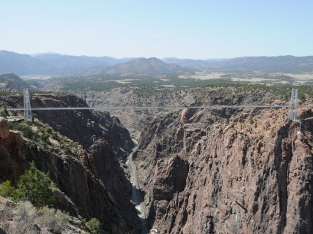
Fig. Royal Gorge Bridge
Meandering Rivers
Meandering Rivers are located on flat terrain that reduces the flow speed of the water, allowing the river to curve or "meander". The bends in the river will migrate back and forth within the river valley. There is a differentiation in flow speeds within a meandering river channel that produces areas of erosion and deposition. There are distinct sedimentary structures that result from this process.
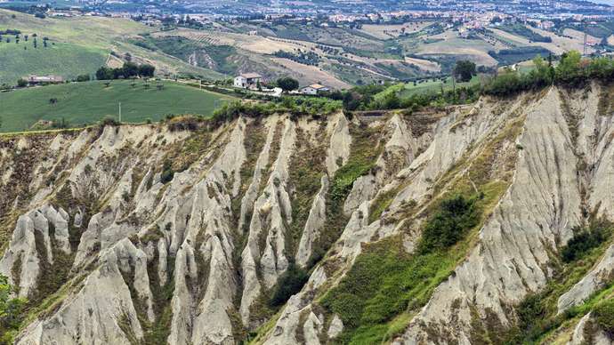
Fig. Aerial photograph of a meandering river.
Q15) Explain sediment erosion in detail.
A15) Sediment Erosion/Deposition
When the water moves around a curve, the velocity of the water is highest along the outer part of the channel. This area is referred to as the bank of the channel, and it is where erosion of sediment occurs. Erosion is caused by the increase in flow velocity, which has the force to erode and transport sediment from the bank. On the inside bend of the river, known as the point bar, water velocity is slower because it doesn't have to travel as far as the water on the outside of the bend. This allows sediment to settle out and be deposited. As this cycle of erosion and deposition continues, the river will migrate in its river valley. This migration can lead to the creation of an oxbow lake.
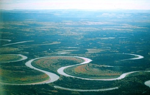
Fig. An oxbow lake
Sedimentary Deposits/Structures
Due to the higher velocity in the middle and outside bend of the river channel, coarser sediment will be deposited in those areas. The coarser grains will be transported to these parts of the river channel because the higher velocity can transport the heavier grains. This is related to the concept of Reynolds Number, which measures whether sediment transport of a specific grain size will be able to occur based on the velocity of the water.
Two distinct areas within the river channel are characterized by different flow speeds and grain size, the outer edge and the inner bend of the channel. The different flow speeds will carry different-sized sediment grains, which will produce an asymmetrical cross-section. The coarser grains will be present in the outer edges of the channel, while finer sediment will be along the inside of the channel. The different flow speeds within the channel, along with the different grain sizes, will produce unique sedimentary structures. The coarser-grained areas that result from a faster flow speed will have upper planar lamination or dune cross-stratification. The point bar of the river will produce current ripple lamination, due to the finer sediment and slower flow speeds. As the river migrates towards the direction of the eroding bank, the current ripples of the point bar will end up being deposited on top of the planar lamination/dune cross-stratification of the bank.
Facies/Stratigraphic Column
The typical facies that occur within a meandering river environment include a scoured base of flow, which is caused by the high flow velocity in the middle of the channel that can pick up and transport large sediment particles. There would also be a lag deposit of mud rip-up clasts and the coarsest sediment within the facies. A lag deposit is where physical processes remove the finer sediment, leaving behind the coarse grains. As we move upward in the stratigraphic column, the grain size will become finer. The structures you should find are trough cross-stratification, rippled sands, and sigmoidal cross-stratification resulting from the point bar migration.
Periodically, the river will flood, causing its floodplain to fill with fine-grained sediment. This is due to the water flow velocity decreasing as it flows away from the river channel. More information on floodplains can be found on the previously linked page on Oxbow Lakes and Floodplains. The floodplain facies will be incorporated into the typical meandering river facies.
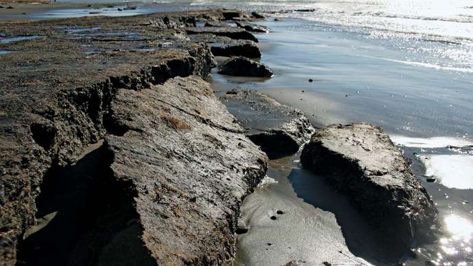
Fig. A typical stratigraphic column for a meandering river system
There are also key differences in the facies for a meandering river channel and a braided river channel. Braided river channels will have coarser grain sizes due to their faster flow speeds. Meandering rivers carry lots of sediment within suspension that will be deposited in the structures associated with this environment, including point bars and oxbow lakes. Lastly, the migration of meandering rivers is more uniform in direction than a braided river because it will always migrate towards the eroding bank. A braided channel will migrate in many directions at the same time.