Unit - 5
Modern Surveying Instruments
Q1) What are the ranges of Electromagnetic spectrum?
A1)
Q2) Explain Electronic Distance Measurement?
A2)
Q3) Explain how to use a theodolite?
A3)
Q4) What is the use of total station?
A4)
Q5) What is the field application of total station?
A5) Following are the field applications of the total station in the area of surveying and other area other then surveying.
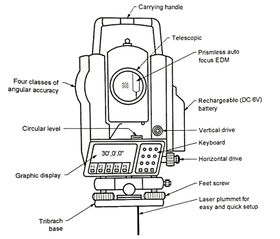
Q6) Explain construction of total station?
A6)

Fig.: total Station
Q7) What are the importance of remote sensing?
A7)
Q8) Explain Basic principle of Remote sensing?
A8)
Q9) Explain an ideal remote sensing system?
A9)
1. A uniform energy source
2. A super sensor
3. A non-interfering atmosphere

Fig.: An ideal remote sensing system
4. Multiple data users
5. A real-time data handling system
Q10) What are the objectives of GIS?
A10) Following are the various objectives of GIS:
Q11) What are the advantages of GIS?
A11)
A GIS can link data sets together by common location of data, such as addresses, which help department and agencies to share their data. By creating a shared database, one department can get benefit from the work of another. In GIS, data can be collected once and used many times.
The old adage "better information leads to better decision" is true for GIS. A GIS is not just an automated decision-making system but a tool to analyze and map data in support of the decision-making process.
GIS is flexible enough to map of any kind of terrain; even the human body. GIS can map any data we wish to make. For example, GIS is used for mapping in which one can find individual feature of object the land like building antennas, towers and landscape etc.