Unit 4
Groundwater
Q1) Explain various zones present in a ground water.
A1)
- Groundwater is water that exists underground in saturated zones below the land surface. The side of the saturated zone is named the geological formation.
- Contrary to well-liked belief, groundwater doesn't kind underground rivers. It fills the pores and fractures in underground materials like sand, gravel, and different rock, abundant an equivalent method that water fills a sponge. If groundwater flows naturally out of rock materials or if it will be removed by pumping (in helpful amounts), the rock materials area unit referred to as aquifers.
- Groundwater moves slowly, usually at rates of 7-60 centimeters (3-25 inches) per day in associate geological formation. As a result, water may stay in associate geological formation for tons of or thousands of years. Groundwater is that the supply of concerning forty p .c of water used for public provides and concerning thirty-nine p .c of water used for agriculture within the U.S.
FORM OF SUBSURFACE WATER
- Sub-surface water (i.e., all kinds of groundwater) will generally classify as:
- The portion in unsaturated zone, (Aeration zone)
- The portion in saturated zone (ground water zone)
UNSATURATED ZONE
- The unsaturated zone contains of 3 underwater zones -soil water zone, Intermediate zone, capillary zone.
SOIL WATER ZONE
- Soil water zone encompasses the zone from the bottom surface all the way down to the roots from wherever water is drawn by vegetation; it's additionally known as soil-moisture belt and its thickness depends upon the kind of vegetation that's being fed. This zone remains unsaturated except in periods of significant infiltration. During this region, soil water is classed in three main classes.
They are:
Hygroscopic water:
- Water is control tightly to the surface of soil particles by sorption forces within the kind of thinnest film with soil water tension regarding thirty one atmosphere and above.
Capillary water:
- Water held by physical phenomenon in the capillary area in the form of a thickest film with tension about 1/3 atmosphere.
Gravitational water:
- Water that moves freely in response to gravity through small pores and drains out soil.
Q2) Explain Intermediate, capillary zone and saturated zone.
A2)
INTERMEDIATE ZONE
- Intermediate zone extends from rock bottom of the soil water zone all the way down to the highest of the capillary fringe
- It greatly varies in thickness from no thickness to many hundred meters.
- All the infiltration water should go through this region.
CAPILLARY ZONE
- Capillary zone is that the zone of soil commencing from the water label to the highest of the capillary rise zones.
- It is the zone that is absolutely saturated at the equilibrium stage; however, the pressure during this zone is a smaller amount than atmospherically thanks to the capillary potential among the capillary fringe. For this reason, this zone is taken as a vicinity of the unsaturated zone.
- Capillary rise depends upon the scale of pores (which may be a perform of soil particle size) and additional on rise fall in water table.
- The thickness of this zone is a function of the feel of soil; therefore, it varies from region to region well as from place to position within a given area.
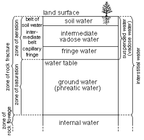
Fig. 1: Form of subsurface water
SATURATED ZONE
- In the saturated zone, H2O fill the pore area fully and water is hold on as during a reservoir have a hydrostatic pressure variation throughout its depths with gas pressure assumed to exist at the water table.
- All earth materials, from soils to rocks have pore spaces. Though these pores are completely saturated water below the water table, from the groundwater utilization purpose of view, solely such material through that water moves simply and thence is Extracted with ease are important On this basis, the saturated formation are classified into four categories.
(1) Aquifer,
(2) Aquitard,
(3) Aquiclude, and
(4) Aquifuge.
Q3) Explain various types of aquifer.
A3)
AQUIFER AND ITS PROPERTIES
TYPES OF AQUIFERS:
Unconfined Aquifers
- Unconfined aquifers are one which signifies the absence of any earth science layer confining the zone of saturation (above the formation). The unconfined formation in direct contact with atmosphere through the zone of aeration. The hydraulic pressure head at any point inside the unconfined aquifer is capable depth of the purpose from the water.
- In unconfined aquifer the water table down if water is withdrawn from the aquifer storage and therefore the water table moves up if water is value-added into the aquifer storage.
- The water level during a massive diameter mamma wells sound unconfined aquifer represents water table. This aquifer is additionally called water table formation or prelatic aquifer.
- A special case of unconfined aquifer is understood as alert aquifer. A perched aquifer is made once the infiltrated rain water is intercept within the zone of Aeration by rubberized layer and a neighborhood zone of saturation is formed. The side of such local zone of saturation is known as perched water table
Confined Aquifers:
- A confined aquifer (also known as trained worker aquifer) is that the one that is land by an impermeable layer or an Aquiclude. In contrast to the unconfined aquifer, the water within the confined aquifer isn't in direct contact with the atmosphere.
- The H2O at intervals a confined geological formation happens besieged (known as confined pressure or trained worker pressure) bigger than atmosphere pressure.
- Once such confined aquifer is punctured by a well, the water rises within the well because of unleash of pressure within confined aquifer. The extent up to that water can rise in the well is understood as potentiometric level. This potentiometric level indicates the magnitude of pressure within the confined aquifer. If the potentiometric level is higher than the bottom surface flowing well results
- The space from which the infiltrated water enters the confined aquifer is known as Recharge area.
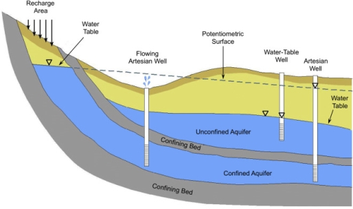
Fig. 2: Unconfined and confined aquifer
Q4) Explain the various properties of aquifer.
A4)
AQUIFER PROPERTIES:
- An aquifer performs 2 functions
1. Storage of water, and
2. Transmission of hold on water.
- The body and also the hydraulic physical phenomenon (permeability) explain the storage and transport of water.
- Porosity
The quantity of pore area per unit volume of the geological formation material is named porosity. It's expressed as
n=Vv /V0
Where n =porosity, Vv =volume of voids and V0= volume of the porous medium.
Specific Yield:
- While porosity provides a live of the water-storage capability of a formation, not all the water command within the pores is offered for extraction by pumping or exhausting by gravity. The pores wait some water by molecular attraction and surface tension.
- The actual volume of water that may be extracted by the force of gravity from a unit volume of geological formation material is understood because the specific yield, S y the fraction of water command back within the aquifer is known as specific retention additionally referred to as cubature unit S r so porosity
n = S y + S r
- Body and specific yield of selected formations
- Note that although clay is additional porous than sand, the distinctive yield of clay is incredibly tiny in distinction to it of sand
- Storage constant (or Storability) (S):
- In case of restricted geological formation extent of water given via unit sketch area of aquifer once piezometric surface falls through oneness is understood as storage coefficient
- For unconfined aquifer storage coefficient is assumed to be adequate bound yield.
- Storage coefficient of associate flowing aquifer is given with the help of the relation.
S =Y w n b (1/K w 1/ n Es)
Where, S= storage coefficient
Y w= precise weight of water
n= porosity of soil
b= thickness of the restrained aquifer
K w= elastic modulus of elasticity of water
Es= modulus of compressible (elasticity) of the soil grains of the geological formation.
Since water is much incompressible expansibility of water because it comes out of the pores includes a little contribution to the value of the storage constant.
Since water is beneath pressure in confined aquifer, exhausting of water results in cut back in pore stress and consequently extend in nice stress. This amplifying in fantastic stress leads to compression of soil Skelton. So Specific storage is totally because of compression of aquifer and growth of water.
Storage coefficient per unit depth of confined aquifer is known as unique storage (S a)
S =S a .b
b= depth of limited aquifer.
Thus sp. Storage is defined as volume of water launched from storage from a unit extent of aquifer due to unit limit in piezometric head,
- Note: When we speak of nicely, we define a new quantity known as particular capacity. Sp. Capacity is the discharge from properly per unit drawdown of well.
Q5) Explain the darcy law
A5)
Darcy Law:
V= K i. ……… (Darcy's law)
Where V= Apparent velocity of seepage = Q/A in which
Q= discharge and
A = cross-sectional region of the porous medium.
V is occasionally also recognized as discharge velocity.
i =-dh/d s = hydraulic gradient,
In which h piezometric head and
s = distance measured in the widespread float direction the terrible sign phasizes that the piezometric head drops in the course of flow.
K=a coefficient, referred to as coefficient of permeable (hydraulic conductivity) having the units of velocity...
The discharge Q can be expressed as
Q=K I A
Darey's law is a precise case of the regularly occurring viscous fluid flow. It has been shown valid for laminar flows only
Darcy law is valid for Re
Re =V d a /v
Where Re = Reynolds number
D a = particle size, usually d a where d, represents a measurement such that 10% of the aquifer cloth is of smaller size.
V = kinematic viscosity of water
Apparent speed V used in Darcy's law is no longer the true speed of float via the pores. Actual velocity journey of water in the porous media is expressed as
U a = V/n
Where n = porosity. The actual velocity u a is the pace that is bought by way of tracking a tracer brought to the ground water.
Coefficient of Permeability:
- The constant of permeableness in addition elaborated as hydraulic physical phenomenon reflects the mixed effects of the porous medium and fluid properties. The coefficient of permeability K may be expressed as
K = Cdm2 Y/u
Where, dm = mean particle activity of the porous medium,
Y= pg = unit weight of fluid flow,
p= density of the fluid,
g = acceleration because of gravity= absolute viscosity of the fluid and C=a
- Structure factor that depends upon on the porosity, packing, formed grain and grain-size distribution of the porous medium.
- The coefficient of permeability is usually viewed in 2 components, one reflective the homes of the medium alone and therefore the different incorporating the fluid properties.
K = KO Y/u
- Where KO = C dm2. The parameter K0 is observed as specific or intrinsic permeableness that could be a feature of the medium only. K0 has dimensions of [L2] it's expressed in gadgets Darcys where, one Darcy 9.87 x 10⁻¹³ me.
- Coefficient of transmissibility (T):
Area of waft =b L
Q= k i A
=K i b L
= (Kb)I L
Q=Ti L
T is termed constant of transmissibility.
Q=T I L
Where, T=Kb
T is called coefficient of transmissibility.
- We apprehend that coefficient of permeableness is represented because the discharge via unit place at a lower place unit hydraulic gradient. But of course water travels thru whole thickness of geological formation (b)
- Hence coefficient of transmissibility is described to get out the discharge. (Co-efferent of transmissibility is so described as, discharge per unit length of geological formation)
T includes a unit of length2 /time.
- Storage constant (S) and transmissibility coefficient (T) are recognized a formation constant of an aquifer and plays very important role within the unsteady waft through porous media.
- Storage coefficient and transmissibility or transmissivity is decided in the subject by means that of concluding pumping take a look at on wells and activity the discharge and decreasing of water stages in the remark wells.
Q6) Explain the process of occurrence of ground water.
A6)
OCCURRENCE OF GROUND WATER
When precipitation falls it may:
(i) be gaseous from the layer or from the leaves of plants (evapotranspiration) whose roots have preoccupied the wetness from the soil;
(ii) Flow on or close to the surface of the planet in watercourses of ever-increasing size till it reaches the ocean;
(iii) Infiltrate down through the pores or crevices of the earth's mantle either at purpose the purpose wherever it falls or at some distant point to that surface flow has carried it.
- Water that evaporates from the layer or bodies of water is prepared to start out the cycle all over again as precipitation.
- When water is value-added to dry or unsaturated soil it's control within the voids between particles by capillary forces. Once the voids are saturated, however, the water is unengaged to descend beneath the result of gravity.
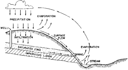
Fig. 3: OCCURRENCE OF GROUP WATER
- As long as there's spare water to take care of saturation, the water can descend till it's stopped by some ladder-proof layer, like rock or extremely ladder-proof clay.
- The water will then flow laterally through the voids or rock crevices on top of the barrier. If there are important variations in surface elevation, the water could effuse on the ladder-proof layer at some lower purpose referred to as a spring. If a hole is formed vertically down into the saturated layer, water can flow into the opening.
- If the saturated layer has spare interconnected voids, water can flow through it comparatively apace. Once the saturated layer yields water in economic quantities, it's referred to as formation and therefore the hole created into it can be developed into a well.
- The dearth of resistance to flow through porous material is named porosity. In general, fine grained material like clay or silt is low in porosity; sand is of medium permeability, and gravel is most permeable.
- Broken rock varies in porosity reckoning on the degree and pattern of fracture. The number of waters which may be hold on in a formation is capable the full volume of voids between the solid particles. The fraction of the full volume of formation created from voids is named consistence. If the voids are interconnected, aquifers of high consistence additionally tend to own high porosity.
- Sometimes groundwater is treed beneath ladder-proof layer. Formation so settled is named a confined formation. If the flow space to a confined formation is above the confining layer wherever a well penetrates it, the water is going to be stressed and can rise within the well to some level on top of the confining layer. Such a well is said as flowing. If the water rises to the highest of the well a "flowing well" results.
- Obviously, some locations provide higher probabilities for in wells than others. Clues which may be useful in choosing well locations are (i) locations and depth to water of existing wells; (ii) existence of springs and/or streams; (iii) relative locations of infiltration areas and rock outcroppings which could represent a ladder-proof layer; and (iv) existence of famed phreatophytes (plants requiring overabundant water, whose roots often touch the water table). In some areas of uniform earth science, like sure deposit deposits in valleys, wells are made anyplace with equal success.
- In the absence of any clues or information, a take a look at boring is administered by one among the ways delineate beneath tiny diameter wells. Such a run of the mill is administered comparatively quickly and cheaply and might save significant time, cash and frustration within the long haul.
- When a well is tense, the water in it drops to some level below the static level. The water surface within the formation then forms a "cone of depression" because it slopes from the static level at some fairly massive radius, R, to the well whose radius is r. If the well utterly penetrates the formation with the static height of water being H and therefore the height of water throughout pumping, h, then theoretical concerns give:
Q = pi K (H2 -h2)/ log e (R/r)
Where:
Q = yield or rate of pumping (e.g. m3/hr, liter/sec, etc.)
K = Permeability of the aquifer
- (H - h) is understood because the "drawdown" of the well. If the drawdown is little compared to H, then the term (H + h) is about capable 2H and therefore the yield, Q, is about proportional to the merchandise of H times the drawdown.
- This shows the importance of penetrating the formation to AN adequate depth. Against this the yield, Q, is way less aware of changes in well diameter, since it's reciprocally proportional to the natural log of the magnitude relation, (R/r).
Q7) Explain hydrogeology and aquifer.
A7)
HYDRO GEOLOGY AND AQUIFER
- Groundwater resources represent arguably the foremost reliable buffer against the unceasing effects of climate change/variability and also the concomitant ramifications on property agriculture particularly within the developing world.
- This is often therefore as a result of groundwater is usually protected against high surface temperatures and also the corresponding high evapotranspiration rates that have an effect on surface flows and impoundments and so render them ineffective sources of irrigation water system to sustain large-scale irrigation activities. Within the lightweight of this, regional hydrogeological studies that cause the event of aquifers for property abstraction and management of groundwater resources is crucial.
- There areas unit numerous approaches obtainable for regional hydrogeological investigations and for providing needed the mandatory info required for optimum geological formation and basin yield management.
- They embrace the applying of remote sensing aerial photography, surface geologic field investigations, application of advanced geology ways, and later drilling to access aquifers.
- The standard follow is that the use of all information obtained from remote sensing techniques along with field based mostly information and borehole info to develop a abstract model that is then born-again into a numerical model to predict the hydrogeological conditions of aquifers.
- Basin wide hydrogeological investigations typically culminate within the development of regionally based mostly numerical groundwater flow models that capture the essential aspects of the regional hydrogeology and so offer call support systems for the management of groundwater resources.
- The employment of models can still offer helpful results in the effective management of flow and matter transport in aquifers, particularly wherever climate change/variability and its attendant effects on the spatial and temporal variations in precipitation patterns place an enormous uncertainty on the property of rain-fed agricultural activities and wherever increasing world temperatures and low humidities render surface impoundments unsustainable as irrigation water sources.
- They're inevitable in large-scale hydrogeological studies that have the objectives of confining some key geological formation storage and hydraulic parameters for higher geological formation characterization.
- In Ghana, erratic precipitation patterns are noted in recent times. This has affected rain-fed agricultural activities in most areas.
- Efforts area unit being created at phasing groundwater resources at affordable depths to satisfy growing domestic water wants while exploring the chances of developing identical resources for large-scale irrigation activities to reinforce agricultural activities.
- This may enhance food security and ultimately contribute to impoverishment reduction within the rural farming communities.
- Towards achieving these objectives, careful hydrogeological investigations are projected to effectively characterize aquifers for correct development of the resource.
- This study forms one among the initial stages of this effort and utilizes a gentle state numerical groundwater flow model to characterize the spatial variations within the hydraulic conductivities of a crystalline basement geological formation in southwestern Republic of Ghana.
- Additionally, to providing an abstract framework of the groundwater flow system within the native setting, the methodology is of international importance because the utility of groundwater models in such end are often applied in alternative terrains.
Q8) Explain ground water movement.
A8)
GROUND WATER MOVEMENT
- The water cycle moves water through the surroundings. As water falls to the bottom as rain or snow – it will escape into streams, lakes, rivers or bays. Water can evaporate from surface water. Water that evaporates, will later condense (called condensation), forming clouds which will cause rain or snow.
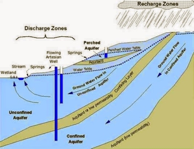
Fig. 4: Ground water movement
- Groundwater and surface water are interconnected. Once the groundwater level rises on top of the bottom, the groundwater discharges to the surface and becomes surface water. Also, once the groundwater level drops, surface water will recharge the groundwater.
- A geological formation is a region of underground soil or rock that's stuffed with water. Associate geological formation will provide water to a drinkable well. Throughout new England New England geographical are geographic area geographical region geographic region there are 2 forms of aquifers want to provide drinkable. These 2 forms of aquifers are sand and gravel aquifers and bedrock aquifers.
- The groundwater level is that the prime of the groundwater. It's the boundary between the saturated zone below the groundwater level and also the unsaturated zone on top of the groundwater level. The groundwater level rises and falls consistent with the time of year and the way abundant rain or snow we tend to get.
- Groundwater is recharged from precipitation – either rain or snow soften -that seeps into the bottom.
- A drinking well may be a circular hole that extends into the bottom till it reaches the groundwater. Wells pump groundwater into our homes. 3 basic well varieties are common throughout New England: mamma, driven and trained wells.
Q9) Explain steady confined flow and steady unconfined flow.
A9)
STEADY AND UNSTEADY FLOW THROUGH CONFINED AND UNCONFINED AQUIFER
Steady Confined Flow (Fully Penetrating Well):
- Full penetrating well means the well which penetrates up to the bottom of the aquifer so that flow is more or less radial
- At a radial distance r from the well, if h is the piezometric head, the velocity of flow by Darcy's law is
V r =K dh/d r
The cylindrical surface through which this velocity occurs is 2πrB. Hence
Q = (2πrB) [K (dh/Dr)]
Q/2πrB (d r/r) =d h
Integrating between limits r1 and r2 with the corresponding piezometric head being h1 and h2 respectively.
Q/2πKB (In r2/r1) = (h2 -h1)
Q = 2πKB (h2 -h1)/ [(In r2/r1)]
- This is the equilibrium equation for the steady flow in confined aquifer. This equation is popularly known as Thiem's equation.
Further, at the edge of the zone of influence, s=0, r 2 =R and h2 =H, at the well wall r1 =r w, h1 =h w and s1 =S w. Hence
Q = 2πKBSw/In (R/r w)
This is called Dupit's formula.
Steady Unconfined Flow:
V r= K (dh/d r)
Q= (2πrh) V r = 2πrKh (dh/d r)
(Q/2πK)(d r/r) =h d h
- Integrating between limits r1 and r2 wherever the water-table depths are h1 and h2 severally and on rearranging
Letter of the alphabet = π K(h22 -h12)/(In r2/r1)
This is that the equilibrium equation for a well in an unconfined formation (Thiems formula). As at the sting of the zone of influence of radius R, H= saturated thickness of the formation Hence
Q = π K (H2-hw2)/In (R/r w)
R is generally between 300-500 m.
Where hectometer = depth of water within the pumping well of radius r w.
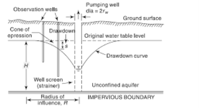
Fig. 5: Unconfined aquifer
NON EOUIABRIUM FORMULA FOR CONFINED AQUIFERS (UNSTEADY RADIAL FLOWS):
- The main disadvantage of the equilibrium formula given by Thiem associate degreed Dupit, was the matter to achieve equilibrium conditions, that isn't a simple to try to the pumping needs to be continued at a standardized rate for a really long time, thus on reach steady flow conditions.
Hence, we tend to adopt non-equilibrium formula as per this
s = Q/4πT [loge (4Tt/r2S)-0.5772]
= Q/4πT × (well function)
Whereas Drawdown within the bralion well once a time t. s7 Well function
Where, s =Drawdown in the observation well after a time t.
T = constant of transmissibility.
Q = constant discharge pumped-up out from the well.
S = coefficient of storage of measured drawdown.
r = Radial distance of the observation well from the most pumped-up well.
If in associate degree observation well at a distance r the drawdown are severally s1 and s2 at time t1 and t2 once the pumping was started within the main well, then
S2 -S1 = Q/4πT loge (t2/t1)
Q10) Explain single, double well system and partially penetrating wall.
A10)
SINGLE AND MULTIPLE WELL SYSTEM
SINGLE WELL SYSTEM
- Most hydraulic pumping systems operate in centralized field facilities (tank batteries, alternative lease-level facilities).
- Sometimes, however, solely many wells in an exceedingly field area unit appropriate for hydraulic pumping, or spacing issues build the employment of centralized facilities impractical. To deal with the constraints of the central battery system, single-well systems are designed.
- These have several of a similar parts as centralized facilities, however are designed for economical use by one, or generally 2 to 3, wells.
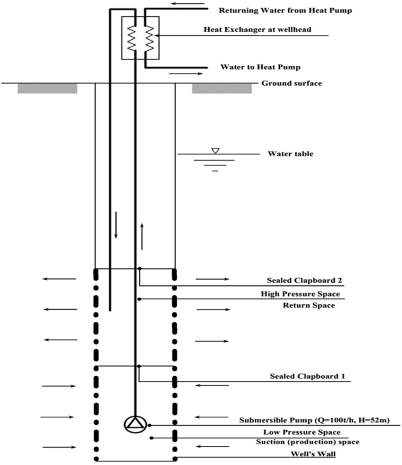
Fig. 6: Single well system
MULTIPLE WELL SYSTEM
- As mentioned earlier, if there areas unit many wells in a very given well field, the drawdown at any purpose is that they add of the draw downs thanks to individual pumping wells.
- The drawdown depends on the pumping pattern, i.e., range of pumping wells, their pumping rates and their arrangement.
- Solutions may be obtained victimization steady-state or unsteady (transient) flow equations counting on the sector state of affairs.
- Multiple well systems area unit used for lowering the water level in a very given space to facilitate undersea evacuation or excavation for foundation work, mining, etc. Steady-state solutions for multiple well systems area unit given during this section for 3 major cases:
(i) drawdown for the well systems parallel to a line supply,
(ii) well discharges for various well configurations, and
(iii) Needed drawdown for the well systems used for dewatering.
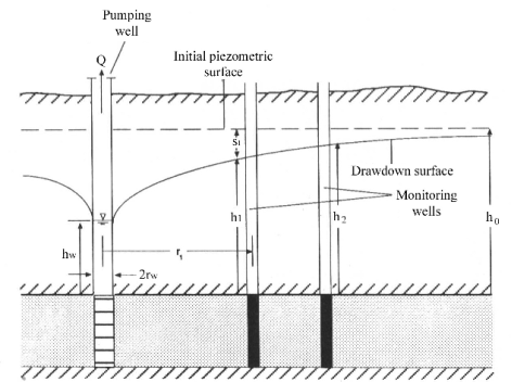
Fig. 7: Multiple well system
PARTIALLY PENETRATING WELL
- In several oil and gas reservoirs the manufacturing wells square measure completed as partly penetrating wells; that's, solely a little of the pay zone is perforated.
- This could be in dire straits a spread of reasons, however the foremost common one is to stop or delay the intrusion of unwanted fluids into the wellbore.
- This paper studies the results of partial penetration on the pressure distribution ensuing penetration on the pressure distribution ensuing from the assembly of a compressible liquid at a relentless rate.
- To modify the mathematical associate analysis the case of one well settled in an infinite reservoir of constant thickness is taken into account, associated it's assumed that this well is perforated over associate interval adjacent to the higher perforated over an interval adjacent to the higher (or lower) rubberized boundary of the formation.
- A well manufacturing from associate absolute interval among the majority of the formation might be treated during a similar approach however this action would just raise the complexities of the answer and contribute very little to the appreciation for the over-all effects of partial penetration.
- During a recently revealed paper, there lot of general drawback of manufacturing from associate absolute interval among the pay zone was studied for the similar steady state flow of a compressible liquid.
- This is often the case during which there's a relentless potential at the boundary and a relentless flux potential at the boundary and a relentless flux across identical boundary.
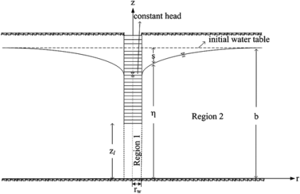
Fig. 8: Partially penetrating well
- This contrasts with the matter studied here, that cares with the matter studied here, That cares with the non steady-state behavior in associate infinite reservoir.
- The exact resolution of the partial penetration drawback presents nice analytics issues as a result of drawback presents nice analytical issues as a result of the boundary conditions that solutions of the partial differential equations should satisfy square measure partial differential equations should satisfy square measure mixed; i.e., on one amongst the boundaries the pressure is given on one portion and therefore the flux on the opposite.
- This problem happens at the wellbore, for the flux over the unproductive section of the well is zero, and therefore the potential over the perforated interval should be constant. Within the case of constant rate production from the well, this uniform potential is time dependent and unknown, and the further condition that
- Where h1 is that the thickness of the perforated interval, should even be glad.
- This drawback could also be overcome within the case of constant rate production by creating the belief that the flux into the well is uniform over the complete perforated interval, in order that on the wellbore the flux perforated interval, in order that on the wellbore the flux is given over the whole formation thickness.