Unit – 4
Photogrammetry Surveying
Q1) What do you mean by photogrammetry survey?
A1) Photogrammetric is a mapping and surveying procedure or technique which has many applications in Transportation Department
Q2) What is relief and tilt displacement in aerial photography?
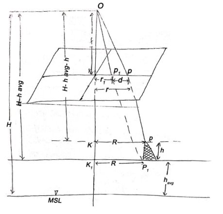
A2)


From (1) and (2)


If the point is taken to datum, (havg – 0)

Shift of Image of a point on photograph, if the point is taken to detum is called relief displacement.
Tilted aerial photograph
f -focal length
n -nadir point
s –swing
p -principal point
t -angle of tilt
i –isocenter
tan (t/2) = (pi)/f; (pi) = f tan (t/2)
tan (t) = (pn)/f; (pn) = f tan (t)
Q3) Explain stereoscopy?
A3)
A combination of stereoscopic photographs or images can be viewed stereoscopically by viewing at the left image with the left eye and the right image with the right eye. It is known stereoscopy.
Stereoscopy is based on Porro-Koppe's Principle that the same light path will be generated through an optical system if a light source is gauge onto the image taken by an optical system. The principle will be realized in a stereo model if a combination of stereoscopic images are reconstructed using the relative location or tilt at the time the photography was taken. Such an adjustment is known relative orientation in photogrammetric terms.
Q4) Explain radial triangulation?
A4)
It is a graphical approach, based on the fact angles measured in a photograph at the iso-centre, located in between of line connecting the principal point and photo-nadir, are true horizontal angles, can be used for planimetric triangulation.
In a vertical photography, the principal point and photo-nadir coincide, that why, the fiducial centre is a suitable approximation of iso-centre for this method. In this method, the principal points of the neighbouring photographs are shift and the horizontal rays can then be drawn for every photo. These planimetric bundles can be put together along a strip or in a block using two ground control points. The other points can be known by multiple intersections.
Q5) What is terrestrial photography?
A5)
Photographs are taken from a stable, usually known as, position on or near the ground and with the camera axis horizontal or nearly so.
The position and orientation of the camera are frequently measured directly at the time of exposure. Instrument used for exposing such photograph is known photo theodolite.
Q6) What do you mean by flight planning?
A6)
Q7) Write short note on mosaics?
A7)
It is an assemblage of aerial photographs whose edges have usually been cut and matched to make a continuous photographic representation of the particular area known a mosaic. If this assemblage is made without any control, then it is known uncontrolled mosaic. If, before being laid, the prints have been properly rectified, i.e., enlarged or decrease, fitted on adequate ground control, i.e., to fit pre-determined position of certain important characteristic \, the mosaic is known to be a controlled mosaic.
The controlled mosaic, more precise, retains the changes in scale and displacements due to differences in relief within the individual prints. A contoured mosaic represents the relief by means of contours, and may be either controlled or uncontrolled. A semi-controlled mosaic may be prepared from unrectified photograph assembled to have ground control; or rectified photographs can be used with no ground control. Semi-controlled mosaics are a compromise in the mid of economy and accuracy.
Q8) Explain aerial triangulation?
A8) The term applied to the process of finding out x, y, and z ground coordinate of each separate points by measuring from the photograph.
The principle behind this application is extending ground control through strip for use in subsequent photogrammetric operation.
Method of Aerial triangulation:
Procedure of Aerial triangulation:

Benefits of aerial triangulation:
Q9) What is map substitutes?
A9) In a situation where there are no adequate large-scale maps available, aerial photographs can take map substitutes in the formation of photomaps.
Limitations:
Q10) Explain types of photogrammetry?
A10) Types of photogrammetry
The camera is mounted in an aircraft, usually pointed perpendicular towards the ground with the camera axis vertical or nearly so.
Many photographs are taken with the clincher – built concept. Later the processing of these photographs done using stereo-plotter.
Photos are also being used in for Digital Elevation Model (DEM) creation.
Photographs are taken from a stable, usually known as, position on or near the ground and with the camera axis horizontal or nearly so.
The position and orientation of the camera are frequently measured directly at the time of exposure. Instrument used for exposing such photograph is known photo theodolite.
In this type of photogrammetry, satellites are used.
Global coverage of satellite image is taken in lesser time with a high-resolution data.
Images are studied and identification is done for judging their significance with standard and careful analysis.