Unit – 5
Remote Sensing
Q1) What is remote sensing?
A1)
Q2) Explain electromagnetic spectrum?
A2) The electromagnetic spectrum is made up of following waves such as
All electromagnetic waves can travel through empty space. Unlike sound waves or water waves, EM waves do not require medium to travel through them. This is important, because EM waves could not travel through empty space, then the light and heat from the Sun would not be able to reach in ground surface.
Q3) What do you mean by visual interpretation?
A3) The visual interpretation of satellite images is a complex process. Visual interpretation is the meaning of the image content by considering the spatial and landscape pattern
Q4) Explain element of visual interpretation?
A4) Element of Remote sensing for visual interpretation and GIS
The various visual elements are as follows:
1) Tone
2) Shape
3) Size
4) Pattern
5) Texture
6) Shadow
7) Association
1) Tone- Tone is the brightness or colour of object in an image. It is the fundamental element to find out different target. Human eye can differentiate 20 to 30 shades of grey tones and more than million colours.
2) Texture-It represents arrangement of and frequency of total variation in a certain area of image.
It is also important for distinguishing features in radar imagery.
Smooth texture example such as fields, grassland.
Rough surface example such as forest.
3) Shapes-It represent outline of an object.
Many components in image or environment can be identified with their shape or forms.
Shape is the very distinctive clue for interpretation.
Example- a) Forest edges- irregular shape
b) Straight edges- agricultural field.
c) Circular shape- rotating sprinkles in land.
4) Size-It is the function of scale.
Example- a) small building represent residential use.
b) last building represents warehouse and factory.
It is an important element to detect the size of target relative to other object in image and also for interpretation of image of target.
5)Shadow - Shadow element helps in or give an idea of relative height of target.
To distinguish show and cloud unfortunately deep shadow observe significant features.
Shadow also helps in identifying topography and landforms.
6)Pattern-It represents spatial arrangement of visibly discernible objects.
A repetition of similar tones and texture will produce a distinctive and recognisable pattern.
Urban Street with regular spaced house is an example of pattern.
7)Association / site-
It is the feature in proximity to the target of interest.
It takes into account the relationship between recognisable objects
Examples such as residential areas would be associated with school, playground, etc. Similarly, lake is associated with boats, Marina etc.
Q5) What is digital processing?
A5) DIP is the use of different algorithms to do image processing on digital images. DIP help in manipulation of the digital images by using computers. three general parts that all types of data have to undergo while using digital technique are
Q6) Difference between platforms and sensor?
A6) Remote sensing platforms can be defined as the structures on which remote sensing instruments that is sensor are placed
Remote sensing systems which measure energy that is naturally available are called passive sensors. Passive sensors are only used to find energy when the naturally occurring energy is presently over there.
Active sensors rely on their own sources of radiation for illuminating objects. The sensor emits radiation towards the target to be investigated. Then the reflected energy from that target is find out and measured by sensor.
Q7) What are the types of platforms?
A7) Types of platforms:
1.Ground-borneplatforms:
It is used to record detailed information about the ground surface which is compared with information collected from aircraft or satellite sensors. Ground observation includes both the laboratory and field study, used for both in designing sensors and identification and types of land features.
Ground observation platforms include –handheld platform, cherry picker, towers, portable masts and vehicles etc.
spectroradiometers and Portable handheld photographic cameras are largely used in laboratory
2.Air-borne platforms:
It is used to collect detailed images and to facilitate the collection of data over virtually any portion of the ground surface at any time. Airborne platforms was the main non-ground-based platforms for early remote sensing work application.
Balloon: -
Balloons are used for remote sensing observation generally for the aerial photography and. The first aerial images captured aloft by a balloon in 1859.
Balloon floats at a constant height of about 30 km. The balloon is control by the wind at the floating height. These techniques are rarely used today because they are not very stable
Drone: -
Drone is a miniature remotely piloted aircraft. It is designed for a low-cost vehicles or platform.
Drone includes equipment of photography, infrared find ion, radar observation and TV surveillance. Drone uses satellite communication link. An onboard computer controls the payload and stores data from different sensors and instruments. it was developed in Britain during World War-II, Now it plays important role in remote sensing.
The different advantage is that it could be easily located above the area and it is capable to provide both night and day data.
Aircraft
Aircraft with cameras and sensors used to capture the aerial photographs and images of ground surface features. While low altitude aerial photography results in large scale images providing detailed information on the terrain, the high-altitude smaller scale images offer advantage to cover a larger area with low spatial resolution.
Multi spectral, hyperspectral and microwave imaging is also done by aircraft.
Aircraft platforms offer an economical method of remote sensing data collection for small to large areas with different tools such as cameras, electronic imagers, across-track and along-track scanners, and scanners.
The AVIRIS hyperspectral imaging is famous and widely used aircraft aerial photographic operation.
High Altitude Sounding Rockets
Balloons have a maximum altitude of approx 37 km, while satellites cannot orbit below 120 km. High altitude sounding rockets is used to moderate altitude above terrain. Imageries with moderate synoptic view can be obtained from such rockets for areas of some 500,000 square kilometers per frame.
high altitude sounding rocket is controlled from a mobile launcher. During the flight its scanning work is done from a stable altitude.
3.Space-borne platforms:
In this platform, sensors are placed on-board a spacecraft orbiting the earth. Space-borne which is also called as satellite platform are one time cost investment but relatively lower cost per unit area of coverage, can cover imager of entire earth. the imaging ranges for space borne platforms are from altitude 250 km to 36000 km.
Spaceborne remote sensing provides the following advantages:
Its coverage large area;
Frequent and repetitive coverage of an area
Processing and analysis are done by Semi-automated computerized
Cost is low for unit area of coverage.
There are two types of well recognized satellite platforms-manned satellite platform and unmanned satellite platform.
Q8) What is digital image?
A8) Digital Image is an image represented by digitally i.e., in groups of combinations bits or by pixels.
Digital Image Processing is the technology of manipulating these groups of pixels to enhance the quality of the image or to find out info from the image digitally, with the help of computer algorithms
Q9) Explain the interaction of electromagnetic radiation with the atmosphere and earth surface?
A9) All wave used for remote sensing passes through the atmosphere before and after it has interacted with the Earth's surface. atmosphere changes the wave or radiation's frequency, intensity, and direction. Radiance measured by an air- or space-borne sensor is affected by various factors, not solely diffuse sky irradiance between the sensor and the target on the ground surface. The atmosphere generally affects the visible and infra-red wavelengths and has more minor effects on microwave wavelength.
There are three physical processes involved:

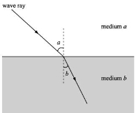
Atmospheric Refraction.

Scattering
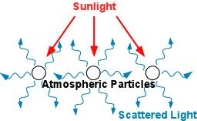
Scattering is the changing or redirection of EM radiation by particles present in the atmosphere. The amount of scattering depends upon the size of the particles present over the atmosphere. The abundance of particles, the wavelength of the electromagnetic radiation, and the depth of the atmosphere all are the factor which governs the scattering.
There are four main types of scattering: -
This type of scattering is caused by gases in the upper atmosphere, or by particles that are smaller than the wavelength of the wave. As shown by the equation below, the degree of scattering is inversely proportional to the fourth power of wavelength (λ)

Q10) What is wavelength and frequency?
A10) The frequency of a wave is the number of times it repeats in one second, and frequency is measured in terms of Hertz (1 Hz = 1 cycle/second).
The wavelength is the distance between successive wave peaks. For electromagnetic waves, wavelength is termed in units of nanometers (nm).