Unit - 4
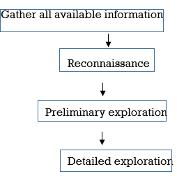
Remote Sensing and G.I.S, Preliminary Geological Studies
Q1. What is remote sensing?
A1.
It is the science of obtaining information about objects or areas from a distance, elevation typically from aircraft or satellites.
Q2. Describe stages of remote sensing?
A2. The procedure of remote sensing involves a number of processes starting from energy emission from source to data analysis and information extraction. The stages has two steps
1. Source of Energy
The source of energy (electromagnetic radiations) is major for the process of remote sensing. The energy sources may be indirect for example sun or direct e.g.:- radar. The indirect sources vary with time and location, on the other hand we have control over direct sources. The direct sources emit electromagnetic radiations (EMRs) in the wavelength regions, which can be sensed by the sensors.
2. Interaction of EMR with the Atmosphere
The EMR interacts with the atmosphere when it travel from the source to earth objects and from earth objects to the sensor. During path the EMR changes its properties due to loss of energy and alteration in wavelength .The interaction often leads to atmospheric noise
3.EMR Interaction with Earth Features
The incident EMR on the earth objects interacts in many ways .Some get reflected, absorbed, transmitted & emitted by the features and ground objects. The amount of EMR reflected, absorbed, transmitted and emitted majorly depends upon the characteristics of the material in contact and EMR itself.
4. Detection of EMR by the remote sensing sensor
The remote sensing device records the EMR which comes to the sensor after its interaction with the earth features.
5. Data Transmission and Processing
The EMR recorded by the remote sensing device is transmitted to earth receiving and data processing stations.
6. Image Processing and Analysis
The digital satellite images are processed using special software meant for satellite image processing. The image processing & analysis of satellite data helps in information extraction.
Q3. What is active and passive sensing?
A3. Passive vs. Active Sensing
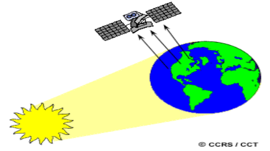
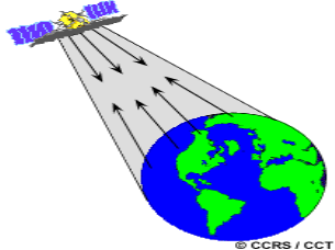
Active sensor, provide own energy source for illumination. The sensor emits radiation which is directed toward the target to be explore. The radiation reflected from that target is detected and compute by the sensor. Benefits for active sensors include the ability to obtain measurements anytime, regardless of the time of day or season. It can be used for examining wavelengths that are not abundantly provided by the sun, such as microwaves, or to better control the way a target is illuminated. Examples of active sensors are a laser fluorosensor and a synthetic aperture radar (SAR).
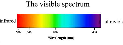
Q4. Explain visible spectrum or band?
A4.
Q5. What is electromagnetic spectrum?
A5.
Radio: Your radio captures radio waves emitted by radio stations, bringing your favourite tunes. It is also emitted by stars and gases in space.
Microwave: Microwave radiation will cook your popcorn in just a few minutes, but is also used by astronomers to learn about the complexities of nearby galaxies.
Infrared: Night vision goggles pick up the infrared light emitted by our skin and objects with heat..
Visible: Our eyes detect visible light. Fireflies, light bulbs, and stars all emit visible light.
Ultraviolet: Ultraviolet radiation is emitted by the Sun and are the reason skin tans and burns.
X-ray: A dentist uses X-rays to image our teeth and airport security uses them to see through your bag.
Gamma ray: Doctors use gamma-ray imaging to see inside your body.
Q6. What is difference between wavelength and frequency?
A6. All electromagnetic waves travel extremely fast through a vacuum, they differ mainly in their wavelength and frequency.
The frequency of a wave is the number of times it repeats in one second, and frequency is measured in terms of Hertz (1 Hz = 1 cycle/second).
The wavelength is the distance between successive wave peaks. For electromagnetic waves, wavelength is termed in units of nanometres (nm).
Q7.What is scattering & absorption of EMR in atmosphere and its effect on Satellite Imagery?
A7. All wave used for remote sensing passes through the atmosphere before and after it has interacted with the Earth's surface. Atmosphere changes the wave or radiation's frequency, intensity, and direction. Radiance measured by an air- or space-borne sensor is affected by various factors, not solely diffuse sky irradiance between the sensor and the target on the ground surface. The atmosphere generally affects the visible and infra-red wavelengths and has more minor effects on microwave wavelength.
There are three physical processes involved:
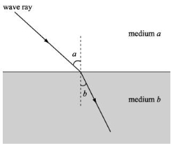
Atmospheric Refraction.
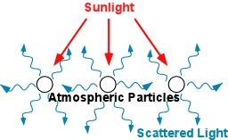
Scattering
Scattering is the changing or redirection of EM radiation by particles present in the atmosphere. The amount of scattering depends upon the size of the particles present over the atmosphere. The abundance of particles, the wavelength of the electromagnetic radiation, and the depth of the atmosphere all are the factor which governs the scattering.
There are four main types of scattering: -
This type of scattering is caused by gases in the upper atmosphere, or by particles that are smaller than the wavelength of the wave. As shown by the equation below, the degree of scattering is inversely proportional to the fourth power of wavelength (λ)

Q8. What are the element of visual interpretation?
A8. The various visual elements are as follows:
1) Tone
2) Shape
3) Size
4) Pattern
5) Texture
6) Shadow
7) Association
1) Tone- Tone is the brightness or colour of object in an image. It is the fundamental element to find out different target. Human eye can differentiate 20 to 30 shades of Grey tones and more than million colours.
2) Texture-It represents arrangement of and frequency of total variation in a certain area of image.
It is also important for distinguishing features in radar imagery.
Smooth texture example such as fields, grassland.
Rough surface example such as forest.
3) Shapes-It represent outline of an object.
Many components in image or environment can be identified with their shape or forms.
Shape is the very distinctive clue for interpretation.
Example- a) Forest edges- irregular shape
b) Straight edges- agricultural field.
c) Circular shape- rotating sprinkles in land.
4) Size-It is the function of scale.
Example- a) Small building represent residential use.
b) Last building represent warehouse and factory.
It is an important element to detect the size of target relative to other object in image and also for interpretation of image of target.
5) Shadow - Shadow element helps in or give an idea of relative height of target.
To distinguish show and cloud unfortunately deep shadow observe significant features.
Shadow also help in identifying topography and landforms.
6) Pattern-It represents spatial arrangement of visibly discernible objects.
A repetition of similar tones and texture will produce a distinctive and recognisable pattern.
Urban Street with regular spaced house is an example of pattern.
7) Association / site-
It is the feature in proximity to the target of interest.
It takes into account the relationship between recognisable objects
Examples such as residential areas would be associated with school, playground, etc. Similarly, lake is associated with boats, Marina etc.
Q9. What is GIS and toolbox of its
A9. A geographic information system (GIS) is a computer system for capturing, storing, checking, and displaying data related to positions on Earth's surface
Toolbox
The Analysis toolbox contains a powerful set of tools that perform the most fundamental GIS operations.
The Analysis toolbox has five toolsets. Each toolset performs specific GIS analysis of feature data.
Toolsets | Description |
The Extract tools let you select features in a feature class or table based on a query (SQL expression) or spatial and attribute extraction. The output features and attributes are stored in a feature class or table. | |
The Overlay toolset contains tools to overlay multiple feature classes to combine, erase, modify, or update spatial features, resulting in a new feature class. New information is created when overlaying one set of features with another. | |
The Pairwise Overlay toolset provides an alternative to some of the tools in the Overlay toolset. | |
The Proximity toolset contains tools that are used to determine the proximity of features within one or more feature classes or between two feature classes. | |
The Statistics toolset contains tools that perform standard statistical analysis on attribute data as well as tools that calculate area, length, and count statistics for overlapping and neighbouring features. |
Q10. Explain surface and subsurface geological investigation?
A10.
(a) Lithology
(b) Groundwater condition
(c) Geological structure
(d) Seismicity of the region
(a) Surface investigation
(b) Subsurface investigation
Significance
1) Photo geology-These are images obtained from satellite survey and aerial survey. Photo geology is done by mapping of vast areas of Globe through satellites.
2) Hydrogeological survey-To find out hydrogeological details of the areas, this survey is used. It includes following surveys-
(a) Location of wells.
(b) Precipitation, evaporation and Runap.
(c) Location and discharge of springs.
(d) Drainage pattern
3) Aerial survey-Photo geological maps methods for surface investigation is widely used nowadays. By cameras and aeroplanes, the entire involving an Engineering study is photographed.
Techniques of correlation for surface and subsurface exploration
Methods of surface investigation

 = resistivity in ohm-cm
R= resistance in ohms
A= cross sectional area (cm2)
L= length of the conductor (cm)
Material | Resistivity (ohm cm) |
Massive rock | >400 |
Shale and clay | 1.0 |
Sea water | 0.3 |
Wet to moist clayey soil | 1.5 – 3.0 |
Procedure
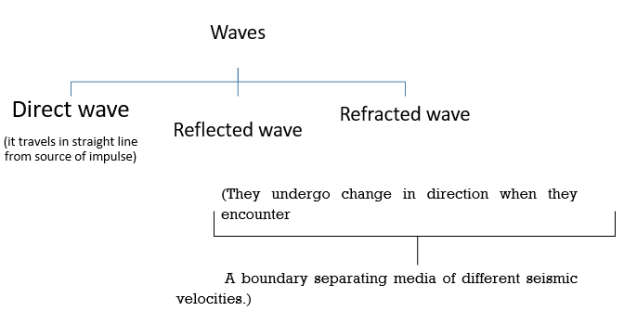
2) Seismic refraction method
(a) Longitudinal or P waves
(b) Transverse or S waves
(c) Surface waves


E= dynamic modulus of soil.
 = Poisson’s ratio
 = density
G= Dynamic shear modulus
Now, waves are classified as:
Assumption involved in this method
1) Soil layer is horizontal
2) Homogenous and isotropic.
3) Layer is sufficiently thick to produce a response.
4) Velocity should increase with depth.
5) Waves follow Snell’s law:

From this method, following things can be find out:
(a) Depth of water table.
(b) Mapping of faults
(c) Depth and characterization of Bedrock.
(d) Burried channel location etc.
From this method following thing can be find out:
(a) Map stratigraphy.
(b) Map salt water intrusion.
(c) Locate voids
(d) Explore for sand and gravel.
(e) Map heavy metals soil contamination.
(f) Map clay aquitards
(g) Estimate landfill thickness.
Seismic survey and its significance and limitations.
Seismic survey, method of investigating structure, particularly as related for petroleum, natural gas, and mineral deposits. This technique is based on finding the time interval that elapses between the initiation of a seismic wave at a selected shot point and the arrival of reflected or refracted impulses at one or more seismic detectors. The technique has largely restore the practice of exploding dynamite underground
The density of rocks near the surface of Earth increases with depth .Seismic waves initiated at a shot point at or near the surface may reach obtained point by reflection, refraction, or both. When the shot point is close to the obtained point, reflected waves reach the receiving point first.
Calculation of the depths and media extend by seismic waves and depends on the distance between shot points and receiving points. The results of a seismic survey may be represented in the form of a cross-sectional drawing of the subsurface structures through the shot point. These drawings are called seismic profiles.
Disadvantages
1. Large quantity of data is collected
2. Data is expensive to acquire
3. Data processing is time consuming and demands expertise
4. Is expensive compared to other geophysical methods
5. Not possible to directly detect contaminants
3) Other surveying methods
(a) Soil temperature: Electronic thermometer is used to find out specific heat of soil. The soil below 45 cm from ground is taken as sample.
(b) Magnetometer: It measures intensity and direction of magnetic force.
(c) Remote Sensing: By aeromagnetic survey and intra red photography.
Limitation of surface investigation:
B. Subsurface Investigation

Significance of subsurface Investigation
1) To identify geologic unit.
2) To identify fault and joint.
3) To identify hydro geologic conditions
4) To identify extent of weathering or density of rock.
5) To install instrumentation.
Methods of Subsurface Investigation
1) Non-Intrusive Method
a) Seismic velocity profiling.
b) Ground Penetrating Radar(GPR)
c) Electromagnetic and resistivity survey.
2) Intrusive Method
a) Drilling, sampling and in site testing
b) Trenching
c) Test pit excavation
d) Drift and shaft.
Planning of exploration of Subsurface
Type of foundation | Depth of exploration |
1. Isolated spread footing or raft. | 1.5B |
2. Pile foundation | 10 to 30m OR 1.5B |
3. Floating basement | Depth of construction |
4. Dams | a) 1.5 times bottom width of dam. |
| b) 2 times height from stream bed to crest for |
| Dam, (Height > 30 cm) |
1) Pit Excavation
2) Trenches
3) Drift and shaft
Drift - To determine structure of geological bed or Strata, a horizontal Tunnel is made in hillsides known as drift.
Size of drift is 1.5m × 2m in hard rock. According to IS 4453 1980.
Shaft- Vertical holes are made.
Usually done for death greater than 4 metres.
4) Boring and drilling- Bore holes are generally located at-
a) Centre of site.
b) building corner
c) Place at which heavily loaded columns are proposed.