Unit - 6
Introduction to Geodetic Survey, Hydrograph Survey & Arial Photogrammetry
Q1) What are the objective of Geodetic surveying?
A1) Following are the important object or purpose of geodetic surveying:
Q2) What is triangulation system?
A2)

Fig.: Well conditioned triangle
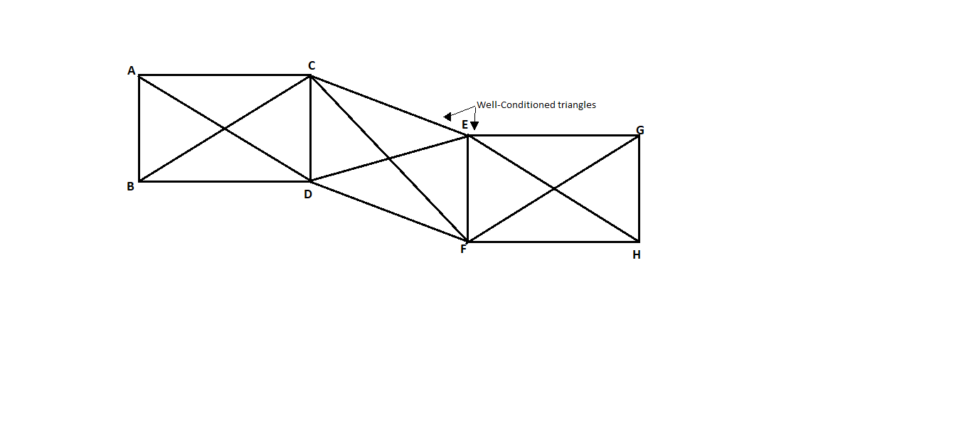
Fig.: Quadrilaterals
Q3) What are the objectives of triangulation survey?
A3) Following are the various uses of triangulation in geodetic surveying.
Q4) Explain the classification of Triangulation system?
A4) Based upon the degree of accuracy required, length of the base, length of the sides, the extent of the area for which the survey to be done, the triangulation system is classified into three divisions, namely-
1. Primary triangulation or first order triangulation
Specification for primary triangulation system:
The common and general specifications for the primary triangular system or first order triangulation are given below:
2. Second order triangulation or secondary triangulation
Specification of secondary triangulation or second order triangulation are given below:
3. Third order triangulation and tertiary triangulation
Specification of third order triangulation and tertiary triangulation:
The common and general specification triangulation are given below:
Q5) Explain Braced Quadrilateral figure?
A5)
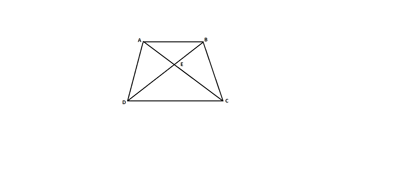
Fig.: Braced Quadrilateral
From Equation (ii), we know,
C = (n'-s'+1) + (n - 2s + 3)
From braced quadrilateral we know,
n= Total number of lines (including known side) = 6,
S = Total number of stations = 4
s' = Number of stations occupied = 4
n' = number of lines observed in both directions including known side 6
∴C = (6-4+1) +(6-2x4+ 3) = 4
D = Number of directions observed (forward and backward) excluding those along known side = 5× 2 = 10
 =0.6
=0.6
Q6) Explain Four-sided central point figure without diagonals?
A6)
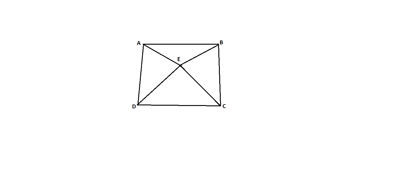
Fig.: Four-sided central point figure without diagonals
Number of backward directions=BA+CB + DC + EC+ EB + EA + ED= 7
D = 7+7= 14, Or D = 2x7= 14
We know,
n = 8, n'=8, s=5, s' = 5
C = (n'-s'+1) + (n +2s + 3) = (8-5+1) + (8-2x5+ 3) = 5
(D-C)/D= (14-5)/14=0.64
Q7) Explain study and use of one second theodolite?
A7) Construction:
Uses:
Q8) Explain study and use of electronic total station?
A8)
Advantages of Total Station over Level and Theodolite:
Use of Total Station:
Q9) What are the objectives of hydrography?
A9) Following are the various purposes or objects of hydrographic survey of the bodies containing still or running water:
Determination of bed depths are also helpful to find the location of underwater works, also helpful to compute the volume of underwater excavation and also useful for the purpose of planning of drainage work and irrigation work.
2. With the help of hydrographic survey, various characteristics and behaviour of bottom of bodies of water can be found out.
3. With the help of hydrographic survey, intensity of tides at sea coast can be measured.
4. With the help of hydrographic survey, areas subjected to scouring and silting can be rectified by determining the direction of current.
5. Hydrographic survey is also useful to measure the velocity, discharge and various characteristics of the flow of water. In such case, measurement of discharge is helpful to water supply schemes, power development, flood control etc.
6. Hydrographic survey is also useful to determine the direction of currents of water. Determination of direction of currents is useful for navigation and for location of sewer outfalls.
Q10) What are the applications of hydrographic survey?
A10) Following are the various applications of hydrographic surveying:
Q11) Explain Shore line survey?
A11) Following are the various objects or purpose of the shoreline survey:
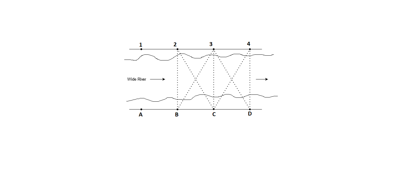
Fig.: Shore line survey
Q12) What is the use of soundings?
A12) Following are the various uses of soundings in hydrographic surveying:
Q13) Explain Sounding Rods?
A13)
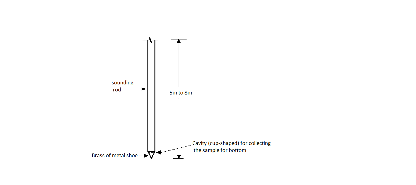
Fig.: Sounding rod with cup shaped cavity
Q14) Explain Fathometer in brief?
A14)
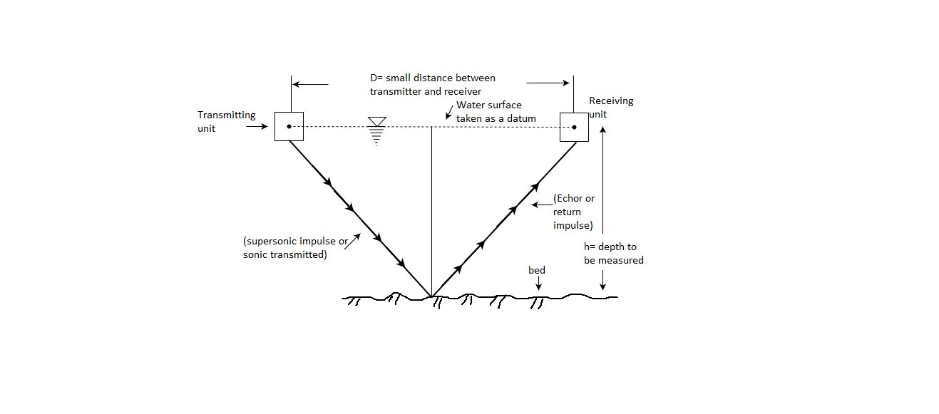
Fig.: Operation of fathometer
The following expression shows the relation with respect to depth (h)
∴h=vt/2
Where,
V = speed of sound in water
T=time interval held between the transmission and reception of the signals.
Note that small correction is needed to apply because distance (D) between transmitter and receiver is small.
Q15) What are the objectives of aerial photogrammetry?
A15) Following are the various objects of aerial photogrammetry:
Q16) What are the classification of aerial photogrammetry?
A16) There are two types of photogrammetry which are as follows:
Terrestrial photogrammetry
Aerial photogrammetry
Q17) What are the application of aerial photogrammetry?
A17)
Q18) Explain comparison of Map and Aerial photograph?
A18)
Sr.No. | Maps | Aerial Photograph |
1 | Maps are plotted by actually taking the linear and angular measurements of the ground and terrain. | A photograph in which a photograph of terrain or ground at the time of exposure and showing all the details of the terrain is
called as aerial
photographs. |
2 | There is no distortion caused by tilt or relief displacement because these maps are prepared after taking the necessary and required measurements. | There is distortion of
details of terrain or ground caused by tilt and relief displacement. |
3 | Contour map which is plotted by carrying actual measurements can be used to determine the elevation of desired objects directly. | Elevation of the different objects or points cannot be taken directly. |
4 | Plotting of map and its reading is common and more familiar to users. Various details of various objects like roads, pond, river, valley, railway crossing, rail-lines, fence etc. can be shown by conventional signs and symbols. | The photo-views so obtained by aerial photographs are not familiar to the eyes of user and it needs a special technique to read the photo-views. |
5 | Plotting of map is economical. | Preparation of maps from aerial photography is uneconomical due to costly automatic plotting machines.
|
6 | Maps can be prepared by conventional methods of surveying. | Aerial photographs are prepared by aerial surveying which is a highly skilled job and also need highly skilled technician. |
7 | Preparation of map is a time-consuming process and need more time. | Preparation of aerial photographs require less time. |
8 | Maps prepared by conventional methods do not depict confusing details and easily recognizable. | Aerial photographs depict confusing details which are not easily identified. |
Q19) What is mean by Crab?
A19) When the camera is not square with respect to the direction of the flight at the time of exposure, then it is called as crab. Fig.(a) and (b) shows the crab and drift respectively.
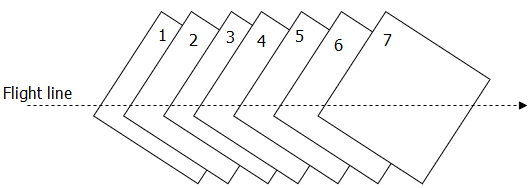
Fig.: Crab
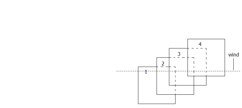
Fig.: Drift
Q20) How we can calculate no. of photograph?
A20)
L = (1-P₁) SI
Where, P=Longitudinal overlap
1 = Length of the photograph in the direction of flight
S = Scale of a photograph
Where, P = Side overlap
S = Scale of a photograph
W =Width of the photograph normal to the direction of flight
Consider N₁ =Number of photographs in each strip
N₂ = Number of strips required
N₁ = +1
+1
Where, L₁= Length of the area
P₁ = Longitudinal overlap
S = Scale of a photograph
1 = Length of the photograph in the direction of flight
N2= +1
+1
Where, B₁= Width of the area
Pw= Side overlap
S = Scale of photograph
W= Width of the photograph normal to the direction of flight
Hence number of photographs required =N₁ X N₂